 Filter: Categories of Wisconsin Historical Images
Filter: Subject of Church buildings
Filter: County of Chippewa
Filter: Categories of Wisconsin Historical Images
Filter: Subject of Church buildings
Filter: County of Chippewa
| Date: | |
|---|---|
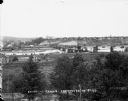
| Description: | Elevated view from south side of the Chippewa River, with a bridge crossing it and buildings on both sides of the river. A bluff rises on the far side of t... |

| Date: | 1874 |
|---|---|
| Description: | Bird's-eye map of Chippewa Falls. |

| Date: | 1895 |
|---|---|
| Description: | View of Methodist Episcopal Church or Emma Suxton Memorial Church. |
| Date: | 1905 |
|---|---|
| Description: | Duncan Creek with McDonnell High School and a church in the background. |
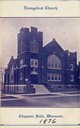
| Date: | 1876 |
|---|---|
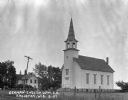
| Description: | Front entrance to the Evangelical Church, founded in approximately 1876. |
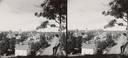
| Date: | 1890 |
|---|---|
| Description: | Elevated view from hill of Grand Avenue. A young boy is posing against a large tree in the right foreground looking out over the town. |

| Date: | 1907 |
|---|---|
| Description: | Elevated view of the business section of Stanley, with a church in the right foreground. |

| Date: | 1905 |
|---|---|
| Description: | Clockwise from upper left images include: Cutters Point, Long Lake, Wis.; M.E. Church, New Auburn, Wis.; Farmers Store, New Auburn, Wis.; Public School, Ne... |

| Date: | 1900 |
|---|---|
| Description: | Interior view of the First Presbyterian Church chancel decorated for Christmas. There are several decorated Christmas trees, an arch and crosses covered wi... |
| Date: | |
|---|---|
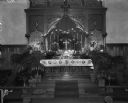
| Description: | The raised altar of the Episcopal Church, with potted palms sitting on the steps. Lilies in vases and candles are displayed on the altar. Elaborate woodwor... |
| Date: | |
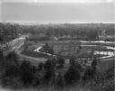
|---|---|
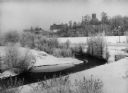
| Description: | Elevated view of park-like, lightly-wooded area with Duncan Creek running through it. A dirt road runs over a bridge to the left. The skyline of Chippewa F... |
| Date: | 1927 |
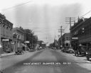
|---|---|
| Description: | View down Main Street lined with shops. Cars are sporadically parked along the curbs. There is a hotel, the Fritzstoldt tailor, soda fountain and drug stor... |
| Date: | 1903 |
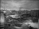
|---|---|
| Description: | View from railroads tracks of the wreckage of wooden buildings left behind after a flood. Intact buildings are visible in a skyline in the distance, and pe... |
| Date: | 1924 |
|---|---|
| Description: | Exterior of the German English Lutheran Church. The church has a gable roof and a steeple with a bell. In the foreground is a fence and field, and in the b... |

| Date: | 1918 |
|---|---|
| Description: | This 1918 map of Chippewa County, Wisconsin, shows the township and range grid, towns, sections, cities and villages, rural residences, churches, schools, ... |

| Date: | 1873 |
|---|---|
| Description: | This 1873 map of Chippewa County, Wisconsin, which at the time also encompassed all or part of Price, Rusk, Sawyer, and Taylor counties, shows the township... |

| Date: | 1902 |
|---|---|
| Description: | This 1902 map of Chippewa County, Wisconsin, shows the township and range grid, towns, sections, cities, villages and post offices, land ownership and acre... |
| Date: | 1909 |
|---|---|
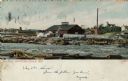
| Description: | Colorized view of Big Mill, a lumber sawmill on the Chippewa river, next to a churning rapids. In the foreground are loose logs, whitewater, river boulders... |
| Date: | 1910 |
|---|---|
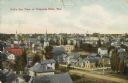
| Description: | Hand-colored elevated view of houses, churches, commercial buildings, unpaved road, sidewalks and fences in central Chippewa Falls. Caption reads: "Bird's ... |

| Date: | 1912 |
|---|---|
| Description: | This blueprint manuscript map shows landownership, mills, railroad, churches, public buildings, the old cemetery, and the Chippewa River and Reservoir. The... |
If you didn't find the material you searched for, our Library Reference Staff can help.
Call our reference desk at 608-264-6535 or email us at: