 Filter: Categories of Wisconsin Historical Images
Filter: Subject of Church buildings
Filter: Community of Milwaukee
Filter: Creator Name of C.N. Caspar Company
Filter: Categories of Wisconsin Historical Images
Filter: Subject of Church buildings
Filter: Community of Milwaukee
Filter: Creator Name of C.N. Caspar Company
| Date: | |
|---|---|
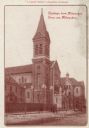
| Description: | N. Fourth Street. Bell tower with clock to the left of the main entrance. Additional buildings are on either side of the main church. Identified on left is... |

| Date: | 1886 |
|---|---|
| Description: | A hand-colored map of Milwaukee County, Wisconsin that shows the township and range system, sections, towns, roads, railroads and rail stations, cities and... |

| Date: | 1891 |
|---|---|
| Description: | A hand-colored map of Milwaukee County, Wisconsin that shows the township and range system, sections, towns, roads, railroads and rail stations, cities and... |

| Date: | 1902 |
|---|---|
| Description: | A map of Milwaukee County, Wisconsin that shows the township and range system, sections, towns, roads, railroads and rail stations, cities and villages, po... |

| Date: | 1904 |
|---|---|
| Description: | This map has three inset maps of Whitefish Bay, Cudahy, and South Milwaukee. This map depicts schools, engine houses, railroads, street railways, city ward... |
If you didn't find the material you searched for, our Library Reference Staff can help.
Call our reference desk at 608-264-6535 or email us at: