 Filter: Categories of Wisconsin Historical Images
Filter: Subject of Children
Filter: Subject of maps
Filter: Categories of Wisconsin Historical Images
Filter: Subject of Children
Filter: Subject of maps
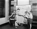
| Date: | 06 07 1938 |
|---|---|
| Description: | Five children looking at map of Presbyterian missions located throughout the world, at Christ Presbyterian Church, located at 124 Wisconsin Avenue. |
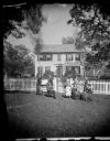
| Date: | 1874 |
|---|---|
| Description: | The Ole Wettlesen family poses in the yard in front of a picket fence with women knitting. Two standing men appear to be examining an unfolded map. The fra... |

| Date: | |
|---|---|
| Description: | A boy sits at a wooden desk to send radio calls at Camp Wallkill. Radio equipment is arranged on the desk and surrounding tables, a radio call book can be... |

| Date: | 09 03 1938 |
|---|---|
| Description: | A group of people at the Indiana State Fair gather around a map of Indiana showing locations for the manufacture of International truck parts. The Internat... |
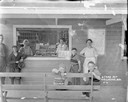
| Date: | |
|---|---|
| Description: | A general store counter at Weigands Bay. Two women are behind the counter, with boxes of cigars on display behind them. Other canned goods are on the shelv... |
| Date: | 1895 |
|---|---|
| Description: | Back cover of catalog for Deering Harvester Company. Features an illustration of men, women and children riding on agricultural machinery pulled by horses.... |
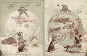
| Date: | 1894 |
|---|---|
| Description: | Front cover featuring a color illustration titled: "Young Canada, 'I wonder what they are doing on the other side,'" and "Merry Christmas." A young boy wea... |

| Date: | 07 1986 |
|---|---|
| Description: | A boy in a classroom wears a red necktie with his school uniform. Other children stand around him also wearing red neckties. |

| Date: | 1746 |
|---|---|
| Description: | Map of North America from the southern portion of James Bay to Florida. It shows the colonies, cities, Native American land, and topological and geographic... |

| Date: | 1683 |
|---|---|
| Description: | Map of the north east coast of North America showing islands, regions, Native American land, bays, and a few European settlements. The Great Lakes appear i... |

| Date: | 1710 |
|---|---|
| Description: | Map of North America showing the European claims, Native American land and villages, rivers, lakes, cities, and notes on explorers, discoveries, and topogr... |

| Date: | 1719 |
|---|---|
| Description: | Map of North America showing land divisions between France, Spain, England, Sweden, Denmark and Holland. The map is detailed, labeling cities, forts, islan... |

| Date: | 1941 |
|---|---|
| Description: | World War II poster published by the National Education Association, showing a teacher working at a globe with a girl and a boy. The boy is holding a book ... |

| Date: | 1957 |
|---|---|
| Description: | Two children are standing and looking at an exhibit that features tools, a map, and some text. Caption reads: "Visitors in the pioneer gallery of the State... |
If you didn't find the material you searched for, our Library Reference Staff can help.
Call our reference desk at 608-264-6535 or email us at: