 Filter: Categories of Wisconsin Historical Images
Filter: Subject of Cheese
Filter: Type of Map or Atlas
Filter: Subject of cities and towns
Filter: Categories of Wisconsin Historical Images
Filter: Subject of Cheese
Filter: Type of Map or Atlas
Filter: Subject of cities and towns

| Date: | 1906 |
|---|---|
| Description: | A commercial map of Wisconsin showing the location of creameries and cheese factories in the state. In the lower portion of the map provides the number of ... |

| Date: | 1896 |
|---|---|
| Description: | A hand-colored Map of Jefferson County, Wisconsin, shows township and section divisions, towns, villages and post offices, rural residents, railroads, road... |
| Date: | 1970 |
|---|---|
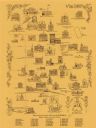
| Description: | This pictorial map shows illustrations of historical landmarks and events, some of which include the fairgrounds, churches, the courthouse, Turner Opera Ho... |

| Date: | 1974 |
|---|---|
| Description: | Map of Wisconsin with drawings illustrating historic places and events throughout the state. The Great Seal of the State of Wisconsin appears at the top ri... |
If you didn't find the material you searched for, our Library Reference Staff can help.
Call our reference desk at 608-264-6535 or email us at: