 Filter: Categories of Wisconsin Historical Images
Filter: Subject of Central business districts
Filter: Reproduction Rights of For Sale
Filter: Creator Name of Nirenstein's National Realty Map Company
Filter: Categories of Wisconsin Historical Images
Filter: Subject of Central business districts
Filter: Reproduction Rights of For Sale
Filter: Creator Name of Nirenstein's National Realty Map Company

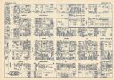
| Date: | 1948 |
|---|---|
| Description: | Map created between 1948 and 1954. Shows businesses and lot owners around the State Capitol. Oriented with north to the upper right. Includes "continued in... |
| Date: | 1930 |
|---|---|
| Description: | This map shows local streets, blocks, lots, local businesses by name, and bus stops. On the back of the map is text, illustrations, and aerial views. |
If you didn't find the material you searched for, our Library Reference Staff can help.
Call our reference desk at 608-264-6535 or email us at: