 Filter: Categories of Wisconsin Historical Images
Filter: Subject of Central business districts
Filter: Community of Milwaukee
Filter: Subject of intellectual life
Filter: Categories of Wisconsin Historical Images
Filter: Subject of Central business districts
Filter: Community of Milwaukee
Filter: Subject of intellectual life
| Date: | |
|---|---|
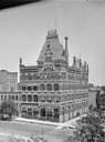
| Description: | Elevated view of the Evening Wisconsin building. There is a horse-drawn vehicle on the left near the curb. |

| Date: | 1965 |
|---|---|
| Description: | Aerial view of early construction at the Marquette Interchange in Milwaukee, the junction of Interstate Highways I94 and I43. Construction began in 1964, ... |

| Date: | |
|---|---|
| Description: | Aerial view of the first Marquette Interchange, photographed some time after its completion in 1968. |
| Date: | |
|---|---|
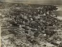
| Description: | Aerial view looking north of downtown, with the Milwaukee River and Lake Michigan. |

| Date: | 1922 |
|---|---|
| Description: | Aerial view of downtown with City Hall and Milwaukee River. |
| Date: | 1940 |
|---|---|
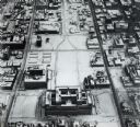
| Description: | Aerial view of courthouse in center foreground with snow on the ground. |

| Date: | 1947 |
|---|---|
| Description: | City Hall near the Milwaukee River. |
| Date: | 1925 |
|---|---|
| Description: | Downtown aerial view with the Milwaukee River and City Hall. Caption reads: "Downtown Aerial View, Milwaukee, Wis." |
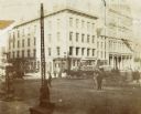
| Date: | 1900 |
|---|---|
| Description: | E. Water and Wisconsin Streets, northwest corner, also called the Ludington Block. John Black's building to extreme right and the Sentinel office between. |

| Date: | 1910 |
|---|---|
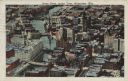
| Description: | Elevated view of downtown. Part of the Milwaukee River is on the left side. Sign for the Germania building is in the lower right, and city hall is in the b... |

| Date: | 06 14 1961 |
|---|---|
| Description: | Aerial view of North and South Harbor Tracts, looking north from South Pier No. 2. There are skyscrapers in the background. there are multiple items of mac... |
If you didn't find the material you searched for, our Library Reference Staff can help.
Call our reference desk at 608-264-6535 or email us at: