 Filter: Categories of Wisconsin Historical Images
Filter: Subject of Central business districts
Filter: Creator Name of Vinje, Arthur M., 1888-1972
Filter: Categories of Wisconsin Historical Images
Filter: Subject of Central business districts
Filter: Creator Name of Vinje, Arthur M., 1888-1972
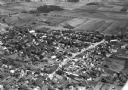
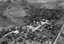
| Date: | 10 1928 |
|---|---|
| Description: | Aerial view of Belleville, including the central business disctrict and the surrounding countryside. |
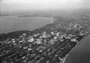
| Date: | 1930 |
|---|---|
| Description: | Aerial view of the city and the Isthmus, the Wisconsin State Capitol, the downtown business district, and both Lake Mendota and Lake Monona. |
| Date: | 1930 |
|---|---|
| Description: | Aerial view of the city, including the Isthmus, the Wisconsin State Capitol, the downtown business district, Lake Mendota, and Lake Monona. |

| Date: | 10 1928 |
|---|---|
| Description: | Aerial view of Sun Prairie, including the central business district, residences, and the surrounding countryside stretching to the horizon. |
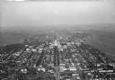
| Date: | 10 1928 |
|---|---|
| Description: | Aerial view of Sun Prairie, including the central business district, residences, and the surrounding countryside. |

| Date: | 1930 |
|---|---|
| Description: | Aerial view of the Wisconsin State Capitol, the surrounding businesses, and Lake Monona. |

| Date: | 1930 |
|---|---|
| Description: | Aerial view of the Wisconsin State Capitol and the surrounding businesses. |

| Date: | 10 1928 |
|---|---|
| Description: | Aerial view of Mount Horeb, including the central business district. |

| Date: | 1930 |
|---|---|
| Description: | Aerial view of the Wisconsin State Capitol and the surrounding businesses. |

| Date: | 11 1928 |
|---|---|
| Description: | Aerial view of Stoughton, including the central business district, residential areas, the Yahara River, and the surrounding countryside. |

| Date: | 1930 |
|---|---|
| Description: | Aerial view of the city with horizon in the far distance. Includes the Wisconsin State Capitol, businesses, Lake Monona, and the surrounding neighborhoods. |

| Date: | 1930 |
|---|---|
| Description: | Aerial view of the town, including the central business district. |
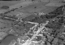
| Date: | 11 1928 |
|---|---|
| Description: | Aerial view of Oregon, including the central business disctrict, residential areas, schools, and the surrounding countryside. |
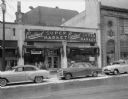
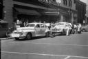
| Date: | 02 23 1955 |
|---|---|
| Description: | Cardinal Super Market, 120 North Fairchild Street. Automobiles are parked along the curb in front. The building on the right is Kessenich's, Inc. |
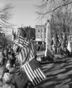
| Date: | 11 11 1952 |
|---|---|
| Description: | Representatives of veterans' and patriotic groups, holding flags and paying tribute to the city's war dead by laying wreaths around a cenotaph at the Stat... |
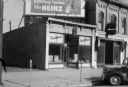
| Date: | 02 21 1944 |
|---|---|
| Description: | Exterior view from street towards the Oscar Fridblom's Health Food Store at a new location, 120 East Washington Avenue. A Heintz ketchup billboard is sitti... |
| Date: | 05 14 1944 |
|---|---|
| Description: | Men doing a periodic rotation of the synthetic and recapped tires on one of the two cars parked in front of the Park Hotel, and participating in the Americ... |
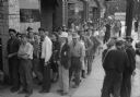
| Date: | 09 15 1944 |
|---|---|
| Description: | Slightly elevated view of customers standing in line on the sidewalk waiting to purchase shotgun shells at Berg Sporting Goods Store, 2123 Atwood Avenue. O... |
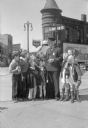
| Date: | 04 12 1945 |
|---|---|
| Description: | Officer Frank B. Ingraham, at his beat on the corners of State, Henry, and Johnson Streets, with young school children from Holy Redeemer School. Ingraham ... |
If you didn't find the material you searched for, our Library Reference Staff can help.
Call our reference desk at 608-264-6535 or email us at:
