Filter: Categories of Wisconsin Historical Images
Filter: Subject of Cemeteries
Filter: Year of 1900-1999
Filter: Categories of Wisconsin Historical Images
Filter: Subject of Cemeteries
Filter: Year of 1900-1999
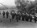
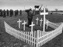
| Date: | 05 1983 |
|---|---|
| Description: | "Theresa American Legion members paid homage to former comrades on Memorial Day at the River Church Cemetery." |
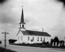
| Date: | 08 02 1956 |
|---|---|
| Description: | Exterior view of the First Lutheran Church at the corner of Old Sauk Road and Pleasant View Road in Middleton, Wisconsin. It was the site of the Middleton ... |

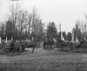
| Date: | 1920 |
|---|---|
| Description: | View across lawn towards Norwegian Lutheran Church and cemetery. Well-dressed men and women stand at the entrance to the building. There are graves behind ... |
| Date: | 04 1900 |
|---|---|
| Description: | The horses and buggies of William Wills, A. Pautz, and Sarah Krueger are at the gate of Oak Hill Cemetery, founded in 1850. |

| Date: | 1946 |
|---|---|
| Description: | A map showing the roads, railroads, towns, cities and villages, streams and lakes, airports, schools, churches, cemeteries, and golf courses in Kenosha Cou... |
| Date: | 1942 |
|---|---|
| Description: | Views of two different bike hosteling trips to Pine Bluff (Dane County) and Lake Mills (Jefferson County), sponsored by Neighborhood House, with girls rest... |

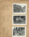
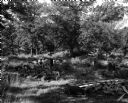
| Date: | 1942 |
|---|---|
| Description: | Four participants (Mary Lou Ciulla, Annie Gambino, Bessie Parisi, and Vita Valenza) of a bike hosteling trip sponsored by Neighborhood House, resting on a ... |
| Date: | 05 26 1997 |
|---|---|
| Description: | "Theresa American Legion Post 270 veterans visited seven cemeteries as they paid homage to departed comrades. Gary Erdman, Sargent-at-arms, stood at attent... |
| Date: | 07 15 1957 |
|---|---|
| Description: | Cemetery caretaker M.F. Chapman points to an undeveloped area west of the veterans' section at Forest Hill Cemetery that has become filled with wood debris... |
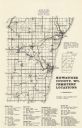
| Date: | 1977 |
|---|---|
| Description: | A map of Kewaunee County, Wisconsin that identifies the locations of 46 cemeteries in the county. The cemeteries are listed by town. |
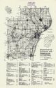
| Date: | 1976 |
|---|---|
| Description: | A map of Manitowoc County, Wisconsin, showing the location of 94 cemeteries in the county. The map also shows major roads that travel to the city of Manito... |

| Date: | 1914 |
|---|---|
| Description: | A hand-drawn and colored map of the Milwaukee Township, showing how lands were used, included are parks, cemeteries, private grounds, and speculative land.... |

| Date: | 1922 |
|---|---|
| Description: | This map from the early to mid-20th century shows the township and range system, towns, cities and villages, roads, railroads, schools, churches, cemeterie... |

| Date: | 1922 |
|---|---|
| Description: | This map of Outagamie County, Wisconsin, from the first half of the 20th century, shows the township and range grid, towns, sections, cities and villages, ... |

| Date: | 1916 |
|---|---|
| Description: | This Wisconsin Conservation Commission map from 1916 shows Peninsula State Park in the Town of Gibraltar, Door County, Wisconsin. Depicted are open and pla... |

| Date: | 1916 |
|---|---|
| Description: | This version of a 1916 Wisconsin Conservation Commission map shows Peninsula State Park in the Town of Gibraltar, Door County, Wisconsin. Depicted are open... |

| Date: | 1913 |
|---|---|
| Description: | This 1913 map of Pepin County, Wisconsin, shows the township and range grid, towns, villages, rural routes, railroads, roads, schools, churches, cemeteries... |

| Date: | 1922 |
|---|---|
| Description: | This map of Pepin County, Wisconsin, from the first half of the 20th century shows the township and range grid, towns, villages, railroads, roads, schools,... |

| Date: | 1922 |
|---|---|
| Description: | This map of Pierce County, Wisconsin, from the first half of the 20th century, shows the township and range grid, towns, sections, villages, roads, railroa... |
If you didn't find the material you searched for, our Library Reference Staff can help.
Call our reference desk at 608-264-6535 or email us at: