 Filter: Categories of Wisconsin Historical Images
Filter: Subject of Cemeteries
Filter: Year of 1800-1899
Filter: Year of 1860-1869
Filter: Categories of Wisconsin Historical Images
Filter: Subject of Cemeteries
Filter: Year of 1800-1899
Filter: Year of 1860-1869
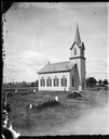
| Date: | 1869 |
|---|---|
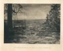
| Description: | View of the McFarland Lutheran church and cemetery. The church was started in 1869 and in use in 1873. It was dedicated on January 23, 1876. The church w... |

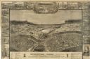
| Date: | 1867 |
|---|---|
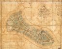
| Description: | Drawn map showing planned development of Cornell, including a couple of schools, Oakwood cemetery, the public square, and several bridges and dams. |
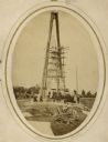
| Date: | 1869 |
|---|---|
| Description: | Governor Lucius Fairchild of Wisconsin and an unidentified group visiting the still uncompleted national monument at Gettysburg, Pennsylvania in 1869. Fair... |
| Date: | 1864 |
|---|---|
| Description: | "Andersonville Prison, Camp Sumter, Ga., as it appeared August 1st 1864 when it contained 35,000 prisoners of war." |
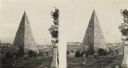
| Date: | 1864 |
|---|---|
| Description: | An albumen stereograph of a monument to the Confederate dead, in the shape of a stone pyramid with steeply pitched sides. |
| Date: | 1866 |
|---|---|
| Description: | The aftermath of the Battle of Peach Tree Creek. Union graves are in the foreground, with a field in the middle, and a forest in the background. Plate 3... |

| Date: | 1868 |
|---|---|
| Description: | A detailed, cloth mounted map of Grant County that shows the townships, towns, roads, completed and under construction railroads, cemeteries, mills, lead m... |

| Date: | 1862 |
|---|---|
| Description: | This 1862 map of Sheboygan County, Wisconsin, shows land ownership and acreages, the township and range grid, towns, cities and villages, roads, railroads,... |
| Date: | 07 1863 |
|---|---|
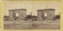
| Description: | Stereograph of the Evergreen Cemetery, a private cemetery in Gettysburg opened in 1855. Because of its location on Cemetery Hill, the highest point in the ... |

| Date: | 1862 |
|---|---|
| Description: | This map shows townships and sections, landownership and acreages, roads, railroads, cemeteries, churches, schools, mills, and stone quarries. "Engraved, p... |

| Date: | 1862 |
|---|---|
| Description: | This 1862 map of Winnebago County, Wisconsin, shows the township and range grid, towns, sections, cities and villages, railroads, roads, property owners an... |

| Date: | 1862 |
|---|---|
| Description: | Shows townships and sections, landownership and acreage, roads, railroads, churches, schools, and cemeteries. Inset maps: Plat of Hingham -- Plat of Casca... |
| Date: | 1865 |
|---|---|
| Description: | This map of Forest Hill Cemetery is ink and watercolor on cloth. The upper right hand margin contains an index by name and lot. The bottom left corner read... |

| Date: | 1860 |
|---|---|
| Description: | This map shows roads, railroads, rivers, townships, school houses, churches, cemeteries, and land ownership by name. Relief is shown by hachures. The map i... |
If you didn't find the material you searched for, our Library Reference Staff can help.
Call our reference desk at 608-264-6535 or email us at: