 Filter: Categories of Wisconsin Historical Images
Filter: Subject of Cemeteries
Filter: Year of 1800-1899
Filter: Creator Name of Unknown
Filter: Categories of Wisconsin Historical Images
Filter: Subject of Cemeteries
Filter: Year of 1800-1899
Filter: Creator Name of Unknown
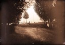
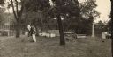
| Date: | 1890 |
|---|---|
| Description: | People in a cemetery. Includes a view of the Scofield family monument. |

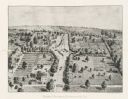
| Date: | 1881 |
|---|---|
| Description: | Bird's-eye map of Milton Junction. |
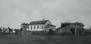
| Date: | 1890 |
|---|---|
| Description: | German Methodist Episcopal Church with a cemetery. The congregation was organized in 1859 and the church was put up in the early 1860's. The church is no l... |
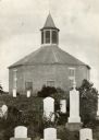
| Date: | 1885 |
|---|---|
| Description: | Norwegian Octagon church, built in 1852 and torn down about 1891 or 1892. |
| Date: | 1895 |
|---|---|
| Description: | Fort Crawford Military Cemetery. Photograph made before restoration by the United States Government. Soldiers' families were also buried in the cemetery. |
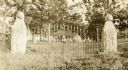
| Date: | 1895 |
|---|---|
| Description: | Fort Crawford Military Cemetery, as seen before it was restored by the United States Government. Two people are standing in the center near the tombs. |
| Date: | 1898 |
|---|---|
| Description: | View through the closed gate, which has a sign that reads: Old Fort Winnebago Cemetery. Overgrown plants surround the gate, and trees surround a monument j... |

| Date: | 1898 |
|---|---|
| Description: | "Confederate Rest" in Forest Hill Cemetery where Confederate prisoners of war who died at Camp Randall are buried. In this early photograph, there is a woo... |
| Date: | 1888 |
|---|---|
| Description: | An overview of the national cemetery in Andersonville. |
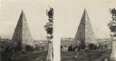
| Date: | 1864 |
|---|---|
| Description: | An albumen stereograph of a monument to the Confederate dead, in the shape of a stone pyramid with steeply pitched sides. |

| Date: | 1870 |
|---|---|
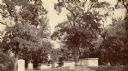
| Description: | View toward the tombstones and a building at Hillside Cemetery and Park. In the foreground is a pond surrounded by vegetation. |

| Date: | 1896 |
|---|---|
| Description: | A hand-colored Map of Jefferson County, Wisconsin, shows township and section divisions, towns, villages and post offices, rural residents, railroads, road... |
| Date: | 1880 |
|---|---|
| Description: | This plat of Vanceburg Cemetery, Town of Sheridan, Dunn County, Wisconsin, likely dates from the 1880s and "is intended for the correction of names of peop... |

| Date: | 1840 |
|---|---|
| Description: | Pen-and-ink on paper. Map shows 1840’s homes with owner names, a Native American cemetery, and other points of interest. Relief shown by hachures. Oriented... |

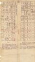
| Date: | 1887 |
|---|---|
| Description: | This map shows landownership, lot and block numbers, wards, cemeteries, and the high school. The map has been removed from Page’s Atlas of Jefferson County... |

| Date: | 1890 |
|---|---|
| Description: | This map shows lot and block numbers and dimensions, landownership, city wards, buildings, streets, railroads, parks, cemeteries, churches, schools, and in... |

| Date: | 1892 |
|---|---|
| Description: | This map shows water pipes, hydrants, stop cocks, check valves, fire cysterns, and manholes. Also shown are block numbers, streets, railroads, parks, cemet... |

| Date: | 1894 |
|---|---|
| Description: | This map shows sewers, intercepting sewers, manholes, block numbers, streets, railroads, parks, cemeteries, and Lake Michigan. The right margin reads: "Tot... |

| Date: | 1879 |
|---|---|
| Description: | This map shows asylums, cemeteries, hospitals, parks, streets, and wards. Relief is shown by contours. Also included are manuscript annotations in pencil. ... |

| Date: | 1896 |
|---|---|
| Description: | This map shows railroads, churches, schools, cemeteries, rivers, lakes, and some rural property owners. |
If you didn't find the material you searched for, our Library Reference Staff can help.
Call our reference desk at 608-264-6535 or email us at: