Filter: Categories of Wisconsin Historical Images
Filter: Subject of Cemeteries
Filter: Subject of transportation
Filter: Categories of Wisconsin Historical Images
Filter: Subject of Cemeteries
Filter: Subject of transportation

| Date: | 1914 |
|---|---|
| Description: | Plat book of Waukesha County. Pages 14 - 15. |
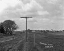
| Date: | |
|---|---|
| Description: | View along fence line of a rural area. There is a road on the left and farmland on the right. A person is traveling down the road, visible as a blur. In th... |

| Date: | 1925 |
|---|---|
| Description: | Elevated view of Coon Valley from a hilltop. Trees are on either side of the frame. In the city, there is a cemetery, church, and field of crops. |

| Date: | 1925 |
|---|---|
| Description: | View of a church, field, and cemetery from a hilltop. A car drives down the road in the lower-right corner. |

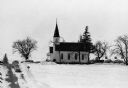
| Date: | |
|---|---|
| Description: | View from hill over church and cemetery towards fields and town in a valley. |
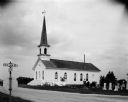
| Date: | 1922 |
|---|---|
| Description: | Exterior of the Methodist Church and the Denzer Cemetery. |
| Date: | 02 16 1978 |
|---|---|
| Description: | "Zion Lutheran Church, Town of Theresa. At this moment, funeral services of Herb Sellnow are taking place." |
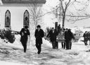
| Date: | 02 16 1978 |
|---|---|
| Description: | "Rev. Herbert Lemke and Charles Koepsell, Mayville, lead the mourners to the grave site." |

| Date: | 1972 |
|---|---|
| Description: | This map on 5 sheets features a title page sheet with business directory and shows section numbers, roads, railroads, saw mills, churches, blacksmith shops... |

| Date: | 1973 |
|---|---|
| Description: | "This winter scene is looking north on Hwy 175 at Union Cemetery." |
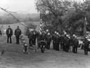
| Date: | 05 1983 |
|---|---|
| Description: | "Theresa American Legion members paid homage to former comrades on Memorial Day at the River Church Cemetery." |
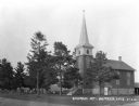
| Date: | 08 02 1956 |
|---|---|
| Description: | Exterior view of the First Lutheran Church at the corner of Old Sauk Road and Pleasant View Road in Middleton, Wisconsin. It was the site of the Middleton ... |

| Date: | 1868 |
|---|---|
| Description: | A detailed, cloth mounted map of Grant County that shows the townships, towns, roads, completed and under construction railroads, cemeteries, mills, lead m... |

| Date: | |
|---|---|
| Description: | A map of Grant County, Wisconsin showing the locations of townships, towns, cities, villages, roads, railroads, schools, cemeteries, churches, rivers, and ... |
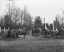
| Date: | 04 1900 |
|---|---|
| Description: | The horses and buggies of William Wills, A. Pautz, and Sarah Krueger are at the gate of Oak Hill Cemetery, founded in 1850. |

| Date: | 1870 |
|---|---|
| Description: | A map of Iowa County, Wisconsin mounted on cloth that shows the villages of Avoca, Mifflin, Linden, Arena, Helena Station, Highland, Dodgeville, as well as... |

| Date: | 1896 |
|---|---|
| Description: | A hand-colored Map of Jefferson County, Wisconsin, shows township and section divisions, towns, villages and post offices, rural residents, railroads, road... |

| Date: | |
|---|---|
| Description: | A road map of Jefferson County, Wisconsin, shows different types of roads, townships and sections, towns, railroads, and cities and villages. Cemetery loca... |

| Date: | 1946 |
|---|---|
| Description: | A map showing the roads, railroads, towns, cities and villages, streams and lakes, airports, schools, churches, cemeteries, and golf courses in Kenosha Cou... |
If you didn't find the material you searched for, our Library Reference Staff can help.
Call our reference desk at 608-264-6535 or email us at: