 Filter: Categories of Wisconsin Historical Images
Filter: Subject of Cemeteries
Filter: Subject of transportation
Filter: Subject of arts
Filter: Categories of Wisconsin Historical Images
Filter: Subject of Cemeteries
Filter: Subject of transportation
Filter: Subject of arts
| Date: | |
|---|---|
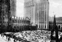
| Description: | Elevated view of a Gothic revival style Trinity church Wall Street and adjacent cemetery. Modern skyscrapers are in the background. |
| Date: | 1922 |
|---|---|
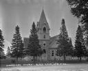
| Description: | Exterior view from road of church. The church building features arched doors and windows, stained glass, and a bell steeple. There is a cemetery behind the... |

| Date: | |
|---|---|
| Description: | This 1907 map of Outagamie County, Wisconsin, shows the township and range grid, towns, sections, cities and villages, railroads, wagon roads, churches, sc... |

| Date: | 1925 |
|---|---|
| Description: | A side view of a Catholic church. Narrow, arched stained-glass windows. Stairs leading up to the entrance. A car is parked by the side entrance with a ceme... |

| Date: | 1970 |
|---|---|
| Description: | This map shows lot and block numbers, city limits, cemeteries, schools, outdoor theater, Lumberjack Bowl, and Historyland among other attractions. |

| Date: | 1789 |
|---|---|
| Description: | Map of New York City showing ward boundaries, ferries, streets, roads, swamps, ponds, and rivers. The properties of Lispinard, Byards, Jones, Rutgers, and ... |
If you didn't find the material you searched for, our Library Reference Staff can help.
Call our reference desk at 608-264-6535 or email us at: