 Filter: Categories of Wisconsin Historical Images
Filter: Subject of Cemeteries
Filter: Subject of transportation
Filter: County of Sauk
Filter: Categories of Wisconsin Historical Images
Filter: Subject of Cemeteries
Filter: Subject of transportation
Filter: County of Sauk
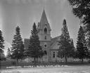
| Date: | 1922 |
|---|---|
| Description: | Exterior view from road of church. The church building features arched doors and windows, stained glass, and a bell steeple. There is a cemetery behind the... |
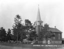
| Date: | 1922 |
|---|---|
| Description: | Exterior of the Methodist Church and the Denzer Cemetery. |

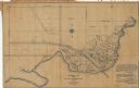
| Date: | 1877 |
|---|---|
| Description: | This 1877 map of Sauk County, Wisconsin, shows the township and range grid, sections, towns, cities and villages, land ownership and acreages, wagon roads,... |
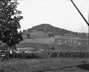
| Date: | 1928 |
|---|---|
| Description: | View down valley of a procession of hundreds of pilgrims walking up the hill to St. Anne's Chapel which is lined with Stations of the Cross. The crowd is w... |
| Date: | 1932 |
|---|---|
| Description: | This blue line print plat map shows local streets, numbered blocks and lots, village limits, and land ownership by name. Also included are manuscript annot... |
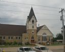
| Date: | 06 23 2012 |
|---|---|
| Description: | Elevated view of a church with arched windows and a cemetery at the side of the building. |
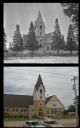
| Date: | |
|---|---|
| Description: | A vintage view and a modern view of a church, presented as a pair. |
If you didn't find the material you searched for, our Library Reference Staff can help.
Call our reference desk at 608-264-6535 or email us at: