 Filter: Categories of Wisconsin Historical Images
Filter: Subject of Cemeteries
Filter: Subject of streets
Filter: Subject of signs and symbols
Filter: Categories of Wisconsin Historical Images
Filter: Subject of Cemeteries
Filter: Subject of streets
Filter: Subject of signs and symbols
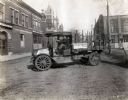
| Date: | 1919 |
|---|---|
| Description: | International model "F" "31" truck operated by Striplins Transfer of Litchfield. A male driver is in the truck which is parked on a city street between a ... |

| Date: | 1911 |
|---|---|
| Description: | View down center of Main Street. On the left is the Hotel Lewis, with a columned porch and awnings above the second-story windows. Further down the street ... |

| Date: | 1964 |
|---|---|
| Description: | This map shows various zoning sections and includes labeled streets, parks, and cemeteries. The upper left corner contains a legend of land use. |

| Date: | 1896 |
|---|---|
| Description: | This map shows streets, wards, railroads, parks, cemeteries, and Lake Michigan. Also included are explanations and an index of points of interest. |

| Date: | 1926 |
|---|---|
| Description: | This map includes a legend in the lower right corner of building heights. Districts marked "A" are 35 foot, districts marked "B" are 45 foot, districts mar... |

| Date: | 1910 |
|---|---|
| Description: | Text on front reads: "Viroqua, Wis." The driveway gate sign reads: "Viroqua Cemetery." The gate, sign and fence are painted a light color. There are many t... |
If you didn't find the material you searched for, our Library Reference Staff can help.
Call our reference desk at 608-264-6535 or email us at: