 Filter: Categories of Wisconsin Historical Images
Filter: Subject of Cemeteries
Filter: Subject of service industries
Filter: Categories of Wisconsin Historical Images
Filter: Subject of Cemeteries
Filter: Subject of service industries

| Date: | 1894 |
|---|---|
| Description: | This map shows sewers, intercepting sewers, manholes, block numbers, streets, railroads, parks, cemeteries, and Lake Michigan. The right margin reads: "Tot... |

| Date: | 1857 |
|---|---|
| Description: | This map shows lot and block numbers, buildings, some land ownership, wards, waterways, streets, railroads, brick yards, and cemeteries. It includes an ind... |

| Date: | 06 12 1929 |
|---|---|
| Description: | This manuscript blueprint shows buildings with the names of their owners, tabernacle, location "where Strang found plates" and "house where Strang died," a... |

| Date: | 1969 |
|---|---|
| Description: | This map shows businesses, resorts, roads, public boat landings, schools, cemeteries, and location of fish and game. An inset map reads: Continuation along... |

| Date: | 1905 |
|---|---|
| Description: | This photocopied map shows landownership, roads, railroads, rural mail routes, churches, school houses, cemeteries, and townships. The map includes adverti... |

| Date: | 1902 |
|---|---|
| Description: | This map shows townships, land parcels, schools, rivers, lakes, creameries, churches, cemeteries, roads, post offices, town halls, saw mills, roads and sto... |
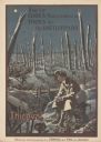
| Date: | 1919 |
|---|---|
| Description: | Poster with an illustration of a British soldier sitting on a battlefield near a trench with barb wire among many destroyed trees at night. There are birds... |

| Date: | |
|---|---|
| Description: | View from shoreline towards a group of men sitting and standing on a seaplane pulled up to the shoreline. The pilot is standing in the cockpit. List of na... |
If you didn't find the material you searched for, our Library Reference Staff can help.
Call our reference desk at 608-264-6535 or email us at: