 Filter: Categories of Wisconsin Historical Images
Filter: Subject of Cemeteries
Filter: Subject of service industries
Filter: Subject of roads
Filter: Categories of Wisconsin Historical Images
Filter: Subject of Cemeteries
Filter: Subject of service industries
Filter: Subject of roads
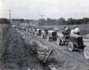
| Date: | 07 25 1925 |
|---|---|
| Description: | A line of International trucks are parked in a line along a dirt road lined with fences and power lines. Each truck has a load of dirt, and metal forms are... |

| Date: | 1870 |
|---|---|
| Description: | A map of Iowa County, Wisconsin mounted on cloth that shows the villages of Avoca, Mifflin, Linden, Arena, Helena Station, Highland, Dodgeville, as well as... |

| Date: | 1896 |
|---|---|
| Description: | This 1896 map of Racine and Kenosha counties, Wisconsin, shows the township and range grid, towns, sections, cities, villages and post offices, roads, rail... |

| Date: | 1862 |
|---|---|
| Description: | This 1862 map of Sheboygan County, Wisconsin, shows land ownership and acreages, the township and range grid, towns, cities and villages, roads, railroads,... |

| Date: | 1878 |
|---|---|
| Description: | This 1878 map of Vernon County, Wisconsin, shows the township and range grid, sections, towns, cities and villages, land ownership and acreages, roads, rai... |

| Date: | 1896 |
|---|---|
| Description: | This late 19th century map of Walworth County, Wisconsin, shows the township and range grid, towns, sections, villages and post offices, roads, railroads, ... |

| Date: | 1878 |
|---|---|
| Description: | This map of Crawford County, Wisconsin, shows the township and range grid, sections, towns, cities and villages, land ownership and acreages, roads, railro... |

| Date: | 1903 |
|---|---|
| Description: | Map of Brown County, Wisconsin, shows the township and range grid, towns, sections, cities, villages and post offices, land owners and acreages, railroads,... |

| Date: | 03 1911 |
|---|---|
| Description: | This 1911 topographic map shows Lake Winnebago and the surrounding area. The township and range grid, counties, towns, sections, cities, villages and post ... |

| Date: | 01 1940 |
|---|---|
| Description: | Map shows roads, railroads, the Fox River, parks, schools, and cemeteries and is indexed by street name in the margins. The bottom of the map show the Winn... |

| Date: | 1939 |
|---|---|
| Description: | This is a zoning map of Wauwatosa with a key of districts including agricultural, resident, business, commercial, and industrial. The map features labeled ... |

| Date: | 1857 |
|---|---|
| Description: | This map shows lot and block numbers, buildings, some land ownership, wards, waterways, streets, railroads, brick yards, and cemeteries. It includes an ind... |

| Date: | 06 12 1929 |
|---|---|
| Description: | This manuscript blueprint shows buildings with the names of their owners, tabernacle, location "where Strang found plates" and "house where Strang died," a... |

| Date: | 1905 |
|---|---|
| Description: | This photocopied map shows landownership, roads, railroads, rural mail routes, churches, school houses, cemeteries, and townships. The map includes adverti... |

| Date: | 1902 |
|---|---|
| Description: | This map shows townships, land parcels, schools, rivers, lakes, creameries, churches, cemeteries, roads, post offices, town halls, saw mills, roads and sto... |
If you didn't find the material you searched for, our Library Reference Staff can help.
Call our reference desk at 608-264-6535 or email us at: