 Filter: Categories of Wisconsin Historical Images
Filter: Subject of Cemeteries
Filter: Subject of service industries
Filter: Creator Name of Unknown
Filter: Categories of Wisconsin Historical Images
Filter: Subject of Cemeteries
Filter: Subject of service industries
Filter: Creator Name of Unknown
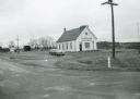
| Date: | 1971 |
|---|---|
| Description: | Spiritland Cafe, a restaurant located in a former church, with the cemetery in the background. The restaurant was located on CTH D in Portage County. |
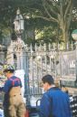
| Date: | 09 2001 |
|---|---|
| Description: | Debris from the collapse of the Twin Towers in the churchyard at St. Paul's Church near the World Trader Center, a few days after 9/11. |

| Date: | 1939 |
|---|---|
| Description: | This is a zoning map of Wauwatosa with a key of districts including agricultural, resident, business, commercial, and industrial. The map features labeled ... |

| Date: | 1892 |
|---|---|
| Description: | This map shows water pipes, hydrants, stop cocks, check valves, fire cysterns, and manholes. Also shown are block numbers, streets, railroads, parks, cemet... |

| Date: | 1894 |
|---|---|
| Description: | This map shows sewers, intercepting sewers, manholes, block numbers, streets, railroads, parks, cemeteries, and Lake Michigan. The right margin reads: "Tot... |

| Date: | |
|---|---|
| Description: | View from shoreline towards a group of men sitting and standing on a seaplane pulled up to the shoreline. The pilot is standing in the cockpit. List of na... |
If you didn't find the material you searched for, our Library Reference Staff can help.
Call our reference desk at 608-264-6535 or email us at: