 Filter: Categories of Wisconsin Historical Images
Filter: Subject of Cemeteries
Filter: Subject of religion
Filter: Year of 1800-1899
Filter: Categories of Wisconsin Historical Images
Filter: Subject of Cemeteries
Filter: Subject of religion
Filter: Year of 1800-1899
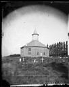
| Date: | 1878 |
|---|---|
| Description: | West Koshkonong Lutheran Church and cemetery. Octagonal stone church built in 1852, rebuilt in 1893, seating 800 people. |
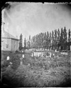
| Date: | 1878 |
|---|---|
| Description: | West Koshkonong Lutheran Church, an octagonal stone church built in 1852 and cemetery. The headstone of Cecilia Martins Datter is legible. Further refere... |
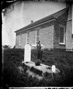
| Date: | 1873 |
|---|---|
| Description: | Norwegian-American farm laborer, Hans Christianson (age 44), stands next to the grave of his childless wife, Karen Luis Christianson, born 1829, who died J... |

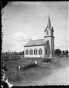
| Date: | 1872 |
|---|---|
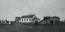
| Description: | View of the Spring Prairie Lutheran Church, built in 1853 and replaced in 1886. |
| Date: | 1869 |
|---|---|
| Description: | View of the McFarland Lutheran church and cemetery. The church was started in 1869 and in use in 1873. It was dedicated on January 23, 1876. The church w... |
| Date: | 1890 |
|---|---|
| Description: | German Methodist Episcopal Church with a cemetery. The congregation was organized in 1859 and the church was put up in the early 1860's. The church is no l... |
| Date: | 1893 |
|---|---|
| Description: | A replication of the crucifixion of Jesus Christ. Depicted is the garden of Joseph of Arimathea and the tomb where Jesus is believed to be the buried. A Ro... |

| Date: | 1857 |
|---|---|
| Description: | This map shows lot and block numbers, buildings, some land ownership, wards, waterways, streets, railroads, brick yards, and cemeteries. It includes an ind... |

| Date: | 1874 |
|---|---|
| Description: | Birds-eye view of Appleton Wisconsin. In the foreground are people fishing, strolling, and looking over the canal towards the Fox River. Streets and buildi... |

| Date: | 1887 |
|---|---|
| Description: | A plat map of Waterford. Township 4, North Range 19, East of 4th Principal Meridian. References at bottom include school houses, houses, churches and cemet... |
If you didn't find the material you searched for, our Library Reference Staff can help.
Call our reference desk at 608-264-6535 or email us at: