Filter: Categories of Wisconsin Historical Images
Filter: Subject of Cemeteries
Filter: Subject of religion
Filter: Subject of land
Filter: Categories of Wisconsin Historical Images
Filter: Subject of Cemeteries
Filter: Subject of religion
Filter: Subject of land
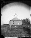
| Date: | 1878 |
|---|---|
| Description: | West Koshkonong Lutheran Church and cemetery. Octagonal stone church built in 1852, rebuilt in 1893, seating 800 people. |

| Date: | 05 10 1928 |
|---|---|
| Description: | The Lutheran Church and buildings, seen from Lutheran Church Hill. |
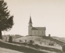
| Date: | 1945 |
|---|---|
| Description: | View of a rural church on a hill and its adjacent cemetery. Beaver Creek Lutheran Church was or still is a Norwegian church. |
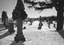
| Date: | 09 11 1927 |
|---|---|
| Description: | A view of the Norwegian Lutheran Cemetery on the site of the Norwegian Lutheran Church, founded in 1852. |
| Date: | 1893 |
|---|---|
| Description: | A replication of the crucifixion of Jesus Christ. Depicted is the garden of Joseph of Arimathea and the tomb where Jesus is believed to be the buried. A Ro... |

| Date: | |
|---|---|
| Description: | Exterior of the Catholic Church. There is a cemetery behind the building. |
| Date: | 1928 |
|---|---|
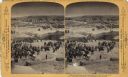
| Description: | View down valley of a procession of hundreds of pilgrims walking up the hill to St. Anne's Chapel which is lined with Stations of the Cross. The crowd is w... |

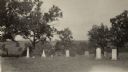
| Date: | 1928 |
|---|---|
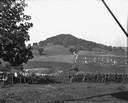
| Description: | View down valley towards the back of the Lutheran Church and cemetery. Houses and barns are in the valley below, and more hills are in the far background. ... |

| Date: | 1900 |
|---|---|
| Description: | This set of maps contains four sheets: "Landownership in the Vicinity of Military Reserve and Fort Howard," "Houses Along the River Road to Green Bay," "Ow... |

| Date: | 1789 |
|---|---|
| Description: | Map of New York City showing ward boundaries, ferries, streets, roads, swamps, ponds, and rivers. The properties of Lispinard, Byards, Jones, Rutgers, and ... |

| Date: | 1874 |
|---|---|
| Description: | Birds-eye view of Appleton Wisconsin. In the foreground are people fishing, strolling, and looking over the canal towards the Fox River. Streets and buildi... |

| Date: | 1887 |
|---|---|
| Description: | A plat map of Waterford. Township 4, North Range 19, East of 4th Principal Meridian. References at bottom include school houses, houses, churches and cemet... |
| Date: | 1963 |
|---|---|
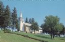
| Description: | Text on the reverse reads: "East Wiota Lutheran Church, South Wayne, Wisconsin 53587. The Oldest Norwegian Lutheran Church in America still in use today. O... |
| Date: | 1910 |
|---|---|
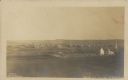
| Description: | Text on front reads: "Bird's Eye View of Strum, Wis." Elevated view of a small town with hills on the horizon. A church and cemetery can be seen on the rig... |
If you didn't find the material you searched for, our Library Reference Staff can help.
Call our reference desk at 608-264-6535 or email us at: