 Filter: Categories of Wisconsin Historical Images
Filter: Subject of Cemeteries
Filter: Subject of religion
Filter: Subject of church buildings
Filter: Categories of Wisconsin Historical Images
Filter: Subject of Cemeteries
Filter: Subject of religion
Filter: Subject of church buildings
| Date: | 1878 |
|---|---|
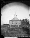
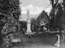
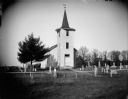
| Description: | West Koshkonong Lutheran Church and cemetery. Octagonal stone church built in 1852, rebuilt in 1893, seating 800 people. |
| Date: | 1878 |
|---|---|
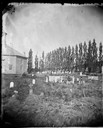
| Description: | West Koshkonong Lutheran Church, an octagonal stone church built in 1852 and cemetery. The headstone of Cecilia Martins Datter is legible. Further refere... |
| Date: | 1873 |
|---|---|
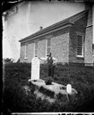
| Description: | Norwegian-American farm laborer, Hans Christianson (age 44), stands next to the grave of his childless wife, Karen Luis Christianson, born 1829, who died J... |

| Date: | 1872 |
|---|---|
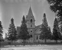
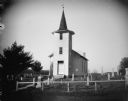
| Description: | View of the Spring Prairie Lutheran Church, built in 1853 and replaced in 1886. |
| Date: | 1920 |
|---|---|
| Description: | German Evangelical Association Church and adjacent cemetery, also known as Zion Evangelical Church. When services were discontinued in the early 1920s the... |
| Date: | |
|---|---|
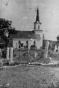
| Description: | View of the church from the cemetery, which has a large monument. A clergyman stands in the doorway of the church. The building is brick, with vines traili... |
| Date: | 1922 |
|---|---|
| Description: | Exterior view from road of church. The church building features arched doors and windows, stained glass, and a bell steeple. There is a cemetery behind the... |

| Date: | |
|---|---|
| Description: | Exterior of the Catholic Church. There is a cemetery behind the building. |
| Date: | 02 16 1978 |
|---|---|
| Description: | "Zion Lutheran Church, Town of Theresa. At this moment, funeral services of Herb Sellnow are taking place." |
| Date: | 08 02 1956 |
|---|---|
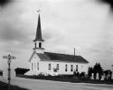
| Description: | Exterior view of the First Lutheran Church at the corner of Old Sauk Road and Pleasant View Road in Middleton, Wisconsin. It was the site of the Middleton ... |

| Date: | 1920 |
|---|---|
| Description: | View across lawn towards Norwegian Lutheran Church and cemetery. Well-dressed men and women stand at the entrance to the building. There are graves behind ... |

| Date: | 1925 |
|---|---|
| Description: | A side view of a Catholic church. Narrow, arched stained-glass windows. Stairs leading up to the entrance. A car is parked by the side entrance with a ceme... |

| Date: | 1928 |
|---|---|
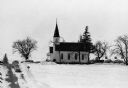
| Description: | View down valley towards the back of the Lutheran Church and cemetery. Houses and barns are in the valley below, and more hills are in the far background. ... |
| Date: | |
|---|---|
| Description: | Outdoor view of a church surrounded by several grave markers. Identified as the Little Norway Lutheran Church. |
| Date: | |
|---|---|
| Description: | Outdoor view of a church surrounded by several grave markers. Identified as the Little Norway Lutheran Church. |

| Date: | 1857 |
|---|---|
| Description: | This map shows lot and block numbers, buildings, some land ownership, wards, waterways, streets, railroads, brick yards, and cemeteries. It includes an ind... |

| Date: | 1905 |
|---|---|
| Description: | This photocopied map shows landownership, roads, railroads, rural mail routes, churches, school houses, cemeteries, and townships. The map includes adverti... |

| Date: | 1902 |
|---|---|
| Description: | This map shows townships, land parcels, schools, rivers, lakes, creameries, churches, cemeteries, roads, post offices, town halls, saw mills, roads and sto... |
| Date: | 06 23 2012 |
|---|---|
| Description: | Elevated view of a church with arched windows and a cemetery at the side of the building. |

| Date: | 1900 |
|---|---|
| Description: | This set of maps contains four sheets: "Landownership in the Vicinity of Military Reserve and Fort Howard," "Houses Along the River Road to Green Bay," "Ow... |
If you didn't find the material you searched for, our Library Reference Staff can help.
Call our reference desk at 608-264-6535 or email us at: