 Filter: Categories of Wisconsin Historical Images
Filter: Subject of Cemeteries
Filter: Subject of persons
Filter: Subject of streams
Filter: Categories of Wisconsin Historical Images
Filter: Subject of Cemeteries
Filter: Subject of persons
Filter: Subject of streams
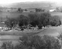
| Date: | 05 30 1967 |
|---|---|
| Description: | View of a parade traveling through a cemetery. Beyond, barns and farmhouses can be seen. |

| Date: | 1946 |
|---|---|
| Description: | A map showing the roads, railroads, towns, cities and villages, streams and lakes, airports, schools, churches, cemeteries, and golf courses in Kenosha Cou... |

| Date: | |
|---|---|
| Description: | This 1907 map of Outagamie County, Wisconsin, shows the township and range grid, towns, sections, cities and villages, railroads, wagon roads, churches, sc... |
If you didn't find the material you searched for, our Library Reference Staff can help.
Call our reference desk at 608-264-6535 or email us at: