 Filter: Categories of Wisconsin Historical Images
Filter: Subject of Cemeteries
Filter: Subject of land use, rural
Filter: Categories of Wisconsin Historical Images
Filter: Subject of Cemeteries
Filter: Subject of land use, rural

| Date: | |
|---|---|
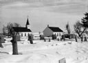
| Description: | View from hill over church and cemetery towards fields and town in a valley. |

| Date: | 02 16 1978 |
|---|---|
| Description: | "Rev. Herbert Lemke and Charles Koepsell, Mayville, lead the mourners to the grave site." |
| Date: | 02 16 1978 |
|---|---|
| Description: | "Zion Cemetery. Herb Sellnow is laid to rest a short distance from the farm where he spent most of his life." |
| Date: | |
|---|---|
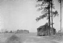
| Description: | Exterior view of a small cabin located near a cotton field. There is a cemetery in the far background. |
| Date: | 05 30 1967 |
|---|---|
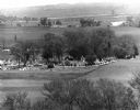
| Description: | View of a parade traveling through a cemetery. Beyond, barns and farmhouses can be seen. |
| Date: | |
|---|---|
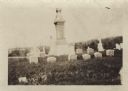
| Description: | Ten graves of the Hedjord family in the Muskego churchyard. There is an obelisk is the center of graves. |
| Date: | |
|---|---|
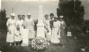
| Description: | Outdoor group portrait of women and one child alongside the graves of Colonel Hans Heg, commander of the 15th Wisconsin Infantry, and his daughter Annetta.... |

| Date: | 1870 |
|---|---|
| Description: | A map of Iowa County, Wisconsin mounted on cloth that shows the villages of Avoca, Mifflin, Linden, Arena, Helena Station, Highland, Dodgeville, as well as... |

| Date: | |
|---|---|
| Description: | The parson came. He said it well: Enough is all we want, to hold and sleep on, not the sky. A little harvest of the sorrows between the sentenc... |
| Date: | 08 2013 |
|---|---|
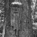
| Description: | Sculpture carved on bark of an oak tree of a bearded man by local artist Peter Dove, who titled it "Hombre Verde." The tree and carving sit in the Natural ... |

| Date: | 1896 |
|---|---|
| Description: | This map shows railroads, churches, schools, cemeteries, rivers, lakes, and some rural property owners. |

| Date: | 1900 |
|---|---|
| Description: | This set of maps contains four sheets: "Landownership in the Vicinity of Military Reserve and Fort Howard," "Houses Along the River Road to Green Bay," "Ow... |

| Date: | 07 25 1925 |
|---|---|
| Description: | View from side of road looking down at a man using a dump truck for road construction. The truck is dumping material in front of a large machine. Men are w... |

| Date: | 07 25 1925 |
|---|---|
| Description: | View from side of road of a line of trucks on a road. There is a large piece of machinery in the background where men are working. In the background is a c... |

| Date: | |
|---|---|
| Description: | View down a long dirt road. In the distance the road passes under a railroad bridge near a church with a cemetery. Caption reads: "Lover's Lane, Mapleton, ... |
If you didn't find the material you searched for, our Library Reference Staff can help.
Call our reference desk at 608-264-6535 or email us at: