 Filter: Categories of Wisconsin Historical Images
Filter: Subject of Cemeteries
Filter: Subject of land
Filter: Subject of agriculture
Filter: Categories of Wisconsin Historical Images
Filter: Subject of Cemeteries
Filter: Subject of land
Filter: Subject of agriculture
| Date: | |
|---|---|
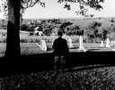
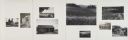
| Description: | Charles Green, the last survivor of the African American colony at Pleasant Ridge (near Lancaster, WI) looks out over the community graveyard. |
| Date: | 1876 |
|---|---|
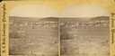
| Description: | A view of the town of Lodi as viewed from the hill north of the cemetery. |

| Date: | 05 10 1928 |
|---|---|
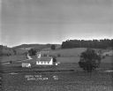
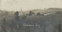
| Description: | The Lutheran Church and buildings, seen from Lutheran Church Hill. |

| Date: | |
|---|---|
| Description: | Elevated view of the town with hills in the distance. In the foreground are cattle inside a fence near a cemetery with a windmill. The town is behind furth... |
| Date: | 1921 |
|---|---|
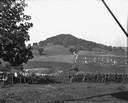
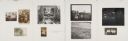
| Description: | View from hill of a church [?], shed, and cemetery in a valley. A dirt road is on the left. |

| Date: | |
|---|---|
| Description: | Elevated city view from an overlooking mountain. A church and cemetery stand among dwellings. |
| Date: | 1913 |
|---|---|
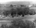
| Description: | View of town. There is a cemetery in the foreground. |
| Date: | 1915 |
|---|---|
| Description: | View of town. A cemetery is in the foreground and a race track is in the center. |

| Date: | 1925 |
|---|---|
| Description: | Elevated view of Coon Valley from a hilltop. Trees are on either side of the frame. In the city, there is a cemetery, church, and field of crops. |
| Date: | 1909 |
|---|---|
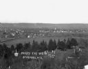
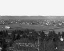
| Description: | Elevated view of a church with cemetery and farmhouses and rolling hills in the distance. Caption reads: "Ashippun, Wis." |

| Date: | 1925 |
|---|---|
| Description: | View of a church, field, and cemetery from a hilltop. A car drives down the road in the lower-right corner. |

| Date: | |
|---|---|
| Description: | View from hill over church and cemetery towards fields and town in a valley. |

| Date: | 02 16 1978 |
|---|---|
| Description: | "The long lens compresses this view from the frozen Rock River in the foreground, the Catholic cemetery, and the Haag farm buildings in the distance." |
| Date: | 05 30 1967 |
|---|---|
| Description: | View of a parade traveling through a cemetery. Beyond, barns and farmhouses can be seen. |

| Date: | 1916 |
|---|---|
| Description: | This Wisconsin Conservation Commission map from 1916 shows Peninsula State Park in the Town of Gibraltar, Door County, Wisconsin. Depicted are open and pla... |

| Date: | 1916 |
|---|---|
| Description: | This version of a 1916 Wisconsin Conservation Commission map shows Peninsula State Park in the Town of Gibraltar, Door County, Wisconsin. Depicted are open... |
| Date: | 1928 |
|---|---|
| Description: | View down valley of a procession of hundreds of pilgrims walking up the hill to St. Anne's Chapel which is lined with Stations of the Cross. The crowd is w... |

| Date: | |
|---|---|
| Description: | New land cut out by real imaginary lines based in older spirit courses lay and bedrock, flight of birds and pointed feet |
| Date: | |
|---|---|
| Description: | The monument is now The place is ripe for building a roll-call of seekers out of the earth For each, his glory is the doing and his dre... |
| Date: | |
|---|---|
| Description: | Although they remembered everything that could not be tolerated, their better natures, surfacing through waves of church-worn care, prevailed over... |
If you didn't find the material you searched for, our Library Reference Staff can help.
Call our reference desk at 608-264-6535 or email us at: