 Filter: Categories of Wisconsin Historical Images
Filter: Subject of Cemeteries
Filter: Subject of intellectual life
Filter: Subject of land
Filter: Categories of Wisconsin Historical Images
Filter: Subject of Cemeteries
Filter: Subject of intellectual life
Filter: Subject of land

| Date: | 1930 |
|---|---|
| Description: | Aerial view of Hoyt Park including the surrounding neighborhoods. Resurrection Cemetery can be seen at the upper right of the image. |

| Date: | 02 06 1948 |
|---|---|
| Description: | Aerial photograph of Madison's west side looking northeast along Speedway Road. Visible are Forest Hill and Resurrection Cemeteries, West High School, Hoyt... |

| Date: | 02 06 1948 |
|---|---|
| Description: | Aerial view of west side, looking south along Glenway Street. Visible are the reservoir, Lake Wingra, Forest Hill and Resurrection Cemetery, Hoyt Park. Maj... |

| Date: | 02 06 1948 |
|---|---|
| Description: | Aerial photograph looking northwest across the reservoir on Glenway Street. Featured are Hoyt and Quarry Parks, Resurrection Cemetery. Major streets are Fr... |

| Date: | 02 06 1948 |
|---|---|
| Description: | Looking north along Glenway Street. Visible are the reservoir, Hoyt and Quarry Parks, Resurrection and Forest Hill Cemeteries, Rentschler Greenhouses, Fore... |

| Date: | 02 06 1948 |
|---|---|
| Description: | Looking southeast across Speedway Road. Visible are the reservoir on Glenway Street, Hoyt Park, Resurrection and Forest Hill cemeteries, Glenway Golf cours... |

| Date: | 02 06 1948 |
|---|---|
| Description: | Looking east along Regent Street with snow on the ground. Visible are Lake Wingra, Monona Bay, railroad causeway across Monona, Lake Mendota, Hoyt Park, We... |

| Date: | 1874 |
|---|---|
| Description: | Bird's-eye view map of Appleton, Wisconsin. Map reads: "NOTE.-Since the above cut was engraved, the Fox River Pulp & Paper Co.'s Mammoth Mills have been er... |

| Date: | 08 1918 |
|---|---|
| Description: | Excavation site of two graves discovered on Bascom Hill during preparation for placement of the Abraham Lincoln monument circle. The legs and shoes of a ma... |

| Date: | 01 1969 |
|---|---|
| Description: | A map of Oneida county, which includes a small drawing of a hodag. |

| Date: | 1874 |
|---|---|
| Description: | Birds-eye view of Appleton Wisconsin. In the foreground are people fishing, strolling, and looking over the canal towards the Fox River. Streets and buildi... |
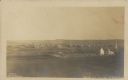
| Date: | 1910 |
|---|---|
| Description: | Text on front reads: "Bird's Eye View of Strum, Wis." Elevated view of a small town with hills on the horizon. A church and cemetery can be seen on the rig... |
If you didn't find the material you searched for, our Library Reference Staff can help.
Call our reference desk at 608-264-6535 or email us at: