 Filter: Categories of Wisconsin Historical Images
Filter: Subject of Cemeteries
Filter: Subject of intellectual life
Filter: Subject of cities and towns
Filter: Categories of Wisconsin Historical Images
Filter: Subject of Cemeteries
Filter: Subject of intellectual life
Filter: Subject of cities and towns

| Date: | 1881 |
|---|---|
| Description: | Bird's-eye map of Milton Junction. |
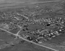
| Date: | 1957 |
|---|---|
| Description: | Air view of town, including multiple buildings and a cemetery. |

| Date: | 1874 |
|---|---|
| Description: | Bird's-eye view map of Appleton, Wisconsin. Map reads: "NOTE.-Since the above cut was engraved, the Fox River Pulp & Paper Co.'s Mammoth Mills have been er... |

| Date: | 1974 |
|---|---|
| Description: | This map shows streets, Lake Winnebago, Little Lake Butte Des Morts, and the Fox River. Also included is text on the Fox River Waterways and the history of... |

| Date: | 01 1969 |
|---|---|
| Description: | A map of Oneida county, which includes a small drawing of a hodag. |

| Date: | 1902 |
|---|---|
| Description: | This map shows townships, land parcels, schools, rivers, lakes, creameries, churches, cemeteries, roads, post offices, town halls, saw mills, roads and sto... |

| Date: | 1874 |
|---|---|
| Description: | Birds-eye view of Appleton Wisconsin. In the foreground are people fishing, strolling, and looking over the canal towards the Fox River. Streets and buildi... |
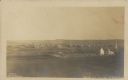
| Date: | 1910 |
|---|---|
| Description: | Text on front reads: "Bird's Eye View of Strum, Wis." Elevated view of a small town with hills on the horizon. A church and cemetery can be seen on the rig... |
If you didn't find the material you searched for, our Library Reference Staff can help.
Call our reference desk at 608-264-6535 or email us at: