 Filter: Categories of Wisconsin Historical Images
Filter: Subject of Cemeteries
Filter: Subject of human settlements
Filter: County of Dodge
Filter: Categories of Wisconsin Historical Images
Filter: Subject of Cemeteries
Filter: Subject of human settlements
Filter: County of Dodge
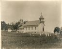
| Date: | |
|---|---|
| Description: | View of the church with the cemetery in the foreground. |
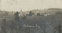
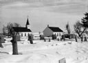
| Date: | 1909 |
|---|---|
| Description: | Elevated view of a church with cemetery and farmhouses and rolling hills in the distance. Caption reads: "Ashippun, Wis." |
| Date: | 02 05 1978 |
|---|---|
| Description: | "Armand Quick, one of Theresa's most famous sons, died in late January and is buried in the family plot at the Catholic Cemetery. Quick was famous for his ... |

| Date: | 02 16 1978 |
|---|---|
| Description: | "The long lens compresses this view from the frozen Rock River in the foreground, the Catholic cemetery, and the Haag farm buildings in the distance." |
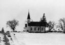
| Date: | 02 16 1978 |
|---|---|
| Description: | "Zion Lutheran Church, Town of Theresa. At this moment, funeral services of Herb Sellnow are taking place." |

| Date: | 02 16 1978 |
|---|---|
| Description: | "Rev. Herbert Lemke and Charles Koepsell, Mayville, lead the mourners to the grave site." |
| Date: | 02 16 1978 |
|---|---|
| Description: | "Zion Cemetery. Herb Sellnow is laid to rest a short distance from the farm where he spent most of his life." |

| Date: | 1899 |
|---|---|
| Description: | This 1899 map of Dodge County, Wisconsin, shows the township and range grid, towns, sections, cities and villages, roads, railroads, post offices, cemeteri... |
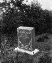
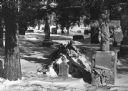
| Date: | 1908 |
|---|---|
| Description: | Monument for Johanna Krueger, the third wife of William Krueger, in Lebanon cemetery. |

| Date: | 11 15 1957 |
|---|---|
| Description: | This map shows single family residence district, business district, and manufacturing district, as well as block and lot numbers, Hustis Homestead, gravel ... |

| Date: | 1910 |
|---|---|
| Description: | A land ownership map of the township of Leroy. |
If you didn't find the material you searched for, our Library Reference Staff can help.
Call our reference desk at 608-264-6535 or email us at:
