 Filter: Categories of Wisconsin Historical Images
Filter: Subject of Cemeteries
Filter: Subject of farms
Filter: Categories of Wisconsin Historical Images
Filter: Subject of Cemeteries
Filter: Subject of farms

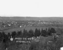
| Date: | 05 10 1928 |
|---|---|
| Description: | The Lutheran Church and buildings, seen from Lutheran Church Hill. |
| Date: | 1970 |
|---|---|
| Description: | A country cemetery with a row of pine trees in the foreground. In the far distance is a farm. |

| Date: | |
|---|---|
| Description: | Elevated view of the town with hills in the distance. In the foreground are cattle inside a fence near a cemetery with a windmill. The town is behind furth... |
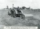
| Date: | 06 1926 |
|---|---|
| Description: | A man uses a McCormick-Deering 10-20 tractor and a Perry automatic scraper to prepare the grounds at Mount Emblem Cemetery. Farm buildings are in the back... |
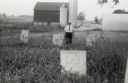
| Date: | 1958 |
|---|---|
| Description: | Local historian William F. Wolf visiting the Native American cemetery. In the background is a barn and a silo and other farm buildings. |
| Date: | 1913 |
|---|---|
| Description: | View of town. There is a cemetery in the foreground. |
| Date: | |
|---|---|
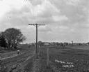
| Description: | View along fence line of a rural area. There is a road on the left and farmland on the right. A person is traveling down the road, visible as a blur. In th... |
| Date: | |
|---|---|
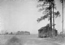
| Description: | Exterior view of a small cabin located near a cotton field. There is a cemetery in the far background. |
| Date: | |
|---|---|
| Description: | The monument is now The place is ripe for building a roll-call of seekers out of the earth For each, his glory is the doing and his dre... |

| Date: | 1947 |
|---|---|
| Description: | This map of Ashland is a cadastral map showing some rural landowners and includes index to points of interest. The map shows roads, railroads, parks, cemet... |
| Date: | 1961 |
|---|---|
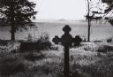
| Description: | Vista over farmland from a small country cemetery. |

| Date: | 1928 |
|---|---|
| Description: | View down valley towards the back of the Lutheran Church and cemetery. Houses and barns are in the valley below, and more hills are in the far background. ... |

| Date: | |
|---|---|
| Description: | The parson came. He said it well: Enough is all we want, to hold and sleep on, not the sky. A little harvest of the sorrows between the sentenc... |

| Date: | |
|---|---|
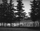
| Description: | View across field towards a long, stone building. There is a small shed behind the building on the left, and a fence is on the right. A person is walking n... |

| Date: | 1910 |
|---|---|
| Description: | A land ownership map of the township of Leroy. |
If you didn't find the material you searched for, our Library Reference Staff can help.
Call our reference desk at 608-264-6535 or email us at:
