 Filter: Categories of Wisconsin Historical Images
Filter: Subject of Cemeteries
Filter: Subject of dwellings
Filter: Subject of water
Filter: Categories of Wisconsin Historical Images
Filter: Subject of Cemeteries
Filter: Subject of dwellings
Filter: Subject of water

| Date: | 02 16 1978 |
|---|---|
| Description: | "The long lens compresses this view from the frozen Rock River in the foreground, the Catholic cemetery, and the Haag farm buildings in the distance." |
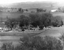
| Date: | 05 30 1967 |
|---|---|
| Description: | View of a parade traveling through a cemetery. Beyond, barns and farmhouses can be seen. |

| Date: | 1868 |
|---|---|
| Description: | A detailed, cloth mounted map of Grant County that shows the townships, towns, roads, completed and under construction railroads, cemeteries, mills, lead m... |

| Date: | 1840 |
|---|---|
| Description: | Pen-and-ink on paper. Map shows 1840’s homes with owner names, a Native American cemetery, and other points of interest. Relief shown by hachures. Oriented... |

| Date: | 1928 |
|---|---|
| Description: | View down valley towards the back of the Lutheran Church and cemetery. Houses and barns are in the valley below, and more hills are in the far background. ... |

| Date: | 06 12 1929 |
|---|---|
| Description: | This manuscript blueprint shows buildings with the names of their owners, tabernacle, location "where Strang found plates" and "house where Strang died," a... |

| Date: | 1887 |
|---|---|
| Description: | A plat map of Waterford. Township 4, North Range 19, East of 4th Principal Meridian. References at bottom include school houses, houses, churches and cemet... |

| Date: | 1910 |
|---|---|
| Description: | A land ownership map of the township of Leroy. |

| Date: | 1891 |
|---|---|
| Description: | The index page of a Sanborn Map of Stevens Point. |
If you didn't find the material you searched for, our Library Reference Staff can help.
Call our reference desk at 608-264-6535 or email us at: