 Filter: Categories of Wisconsin Historical Images
Filter: Subject of Cemeteries
Filter: Subject of cities and towns
Filter: Year of 1800-1899
Filter: Categories of Wisconsin Historical Images
Filter: Subject of Cemeteries
Filter: Subject of cities and towns
Filter: Year of 1800-1899

| Date: | 1881 |
|---|---|
| Description: | Bird's-eye map of Milton Junction. |
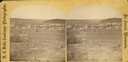
| Date: | 1876 |
|---|---|
| Description: | A view of the town of Lodi as viewed from the hill north of the cemetery. |
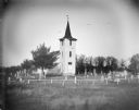
| Date: | 1890 |
|---|---|
| Description: | Little Norway Church, with graveyard, located south of Black River Falls. |

| Date: | 1867 |
|---|---|
| Description: | Drawn map showing planned development of Cornell, including a couple of schools, Oakwood cemetery, the public square, and several bridges and dams. |
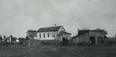
| Date: | 1890 |
|---|---|
| Description: | German Methodist Episcopal Church with a cemetery. The congregation was organized in 1859 and the church was put up in the early 1860's. The church is no l... |
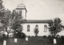
| Date: | 1876 |
|---|---|
| Description: | East Blue Mounds Lutheran Church, formerly Norsk Evangelisk Kirke, built in 1868. The graves of Andreas L. Dahl's mother, Berthe Nelsdatter (Lund) Dahlen, ... |
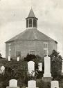
| Date: | 1885 |
|---|---|
| Description: | Norwegian Octagon church, built in 1852 and torn down about 1891 or 1892. |
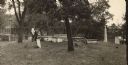
| Date: | 1895 |
|---|---|
| Description: | Fort Crawford Military Cemetery. Photograph made before restoration by the United States Government. Soldiers' families were also buried in the cemetery. |
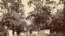
| Date: | 1895 |
|---|---|
| Description: | Fort Crawford Military Cemetery, as seen before it was restored by the United States Government. Two people are standing in the center near the tombs. |
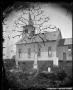
| Date: | 1898 |
|---|---|
| Description: | Exterior view of Zwingli Reformed Church and cemetery. |

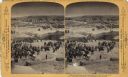
| Date: | 1898 |
|---|---|
| Description: | "Confederate Rest" in Forest Hill Cemetery where Confederate prisoners of war who died at Camp Randall are buried. In this early photograph, there is a woo... |
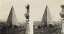
| Date: | 1864 |
|---|---|
| Description: | An albumen stereograph of a monument to the Confederate dead, in the shape of a stone pyramid with steeply pitched sides. |

| Date: | 1870 |
|---|---|
| Description: | View toward the tombstones and a building at Hillside Cemetery and Park. In the foreground is a pond surrounded by vegetation. |
| Date: | 1893 |
|---|---|
| Description: | A replication of the crucifixion of Jesus Christ. Depicted is the garden of Joseph of Arimathea and the tomb where Jesus is believed to be the buried. A Ro... |

| Date: | 1868 |
|---|---|
| Description: | A detailed, cloth mounted map of Grant County that shows the townships, towns, roads, completed and under construction railroads, cemeteries, mills, lead m... |

| Date: | 1870 |
|---|---|
| Description: | A map of Iowa County, Wisconsin mounted on cloth that shows the villages of Avoca, Mifflin, Linden, Arena, Helena Station, Highland, Dodgeville, as well as... |

| Date: | 1896 |
|---|---|
| Description: | A hand-colored Map of Jefferson County, Wisconsin, shows township and section divisions, towns, villages and post offices, rural residents, railroads, road... |

| Date: | 1858 |
|---|---|
| Description: | This 1858 map of Racine County, Wisconsin, shows land ownership and acreages, the township and range grid, towns, cities and villages, roads, railroads, sc... |

| Date: | 1896 |
|---|---|
| Description: | This 1896 map of Racine and Kenosha counties, Wisconsin, shows the township and range grid, towns, sections, cities, villages and post offices, roads, rail... |

| Date: | 1876 |
|---|---|
| Description: | This 1876 map of Saint Croix County, Wisconsin, shows the township and range grid, sections, towns, cities and villages, land ownership and acreages, wagon... |
If you didn't find the material you searched for, our Library Reference Staff can help.
Call our reference desk at 608-264-6535 or email us at: