 Filter: Categories of Wisconsin Historical Images
Filter: Subject of Cemeteries
Filter: Subject of cities and towns
Filter: Subject of farms
Filter: Categories of Wisconsin Historical Images
Filter: Subject of Cemeteries
Filter: Subject of cities and towns
Filter: Subject of farms

| Date: | 05 10 1928 |
|---|---|
| Description: | The Lutheran Church and buildings, seen from Lutheran Church Hill. |

| Date: | |
|---|---|
| Description: | Elevated view of the town with hills in the distance. In the foreground are cattle inside a fence near a cemetery with a windmill. The town is behind furth... |
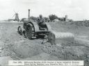
| Date: | 06 1926 |
|---|---|
| Description: | A man uses a McCormick-Deering 10-20 tractor and a Perry automatic scraper to prepare the grounds at Mount Emblem Cemetery. Farm buildings are in the back... |
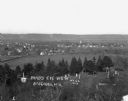
| Date: | 1913 |
|---|---|
| Description: | View of town. There is a cemetery in the foreground. |
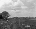
| Date: | |
|---|---|
| Description: | View along fence line of a rural area. There is a road on the left and farmland on the right. A person is traveling down the road, visible as a blur. In th... |

| Date: | 1947 |
|---|---|
| Description: | This map of Ashland is a cadastral map showing some rural landowners and includes index to points of interest. The map shows roads, railroads, parks, cemet... |

| Date: | 1928 |
|---|---|
| Description: | View down valley towards the back of the Lutheran Church and cemetery. Houses and barns are in the valley below, and more hills are in the far background. ... |

| Date: | 1910 |
|---|---|
| Description: | A land ownership map of the township of Leroy. |
If you didn't find the material you searched for, our Library Reference Staff can help.
Call our reference desk at 608-264-6535 or email us at: