 Filter: Categories of Wisconsin Historical Images
Filter: Subject of Cemeteries
Filter: Subject of cities and towns
Filter: Community of Milwaukee
Filter: Categories of Wisconsin Historical Images
Filter: Subject of Cemeteries
Filter: Subject of cities and towns
Filter: Community of Milwaukee

| Date: | 1914 |
|---|---|
| Description: | A hand-drawn and colored map of the Milwaukee Township, showing how lands were used, included are parks, cemeteries, private grounds, and speculative land.... |

| Date: | 1840 |
|---|---|
| Description: | Pen-and-ink on paper. Map shows 1840’s homes with owner names, a Native American cemetery, and other points of interest. Relief shown by hachures. Oriented... |

| Date: | 1936 |
|---|---|
| Description: | Street map of the City of Milwaukee and surrounding suburbs indicating various mass transit lines. There is an index to Milwaukee streets at the right of t... |

| Date: | 1934 |
|---|---|
| Description: | This map is attached to a cover. Streets, points of interest, the Milwaukee River, and Lake Michigan are labeled. The bottom margin of the map includes a s... |

| Date: | 1892 |
|---|---|
| Description: | This map shows water pipes, hydrants, stop cocks, check valves, fire cysterns, and manholes. Also shown are block numbers, streets, railroads, parks, cemet... |

| Date: | 1892 |
|---|---|
| Description: | This map shows schools, engine houses, railroads, street railways, wards, parks, cemeteries, block numbers, a street index, explanations, and general refer... |

| Date: | 1893 |
|---|---|
| Description: | This map shows city wards, block numbers, parks, cemeteries, roads, railroads, selected buildings, and Lake Michigan. Also included are indexes to streets,... |

| Date: | 1897 |
|---|---|
| Description: | This map shows city wards, block numbers, parks, cemeteries, roads, railroads, Lake Michigan, and selected buildings. Also included are indexes to streets,... |

| Date: | 1898 |
|---|---|
| Description: | This map shows city wards, block numbers, parks, cemeteries, roads, railroads, Lake Michigan, and selected buildings. Also included are indexes "Milwaukee ... |

| Date: | 1900 |
|---|---|
| Description: | This map shows city wards, block numbers, parks, cemeteries, roads, railroads, Lake Michigan, and selected buildings. Also included are indexes "Milwaukee ... |

| Date: | 1901 |
|---|---|
| Description: | This map shows city wards, block numbers, parks, cemeteries, roads, railroads, Lake Michigan, and selected buildings. Also included are indexes "Milwaukee ... |

| Date: | 1904 |
|---|---|
| Description: | This map shows wards, schools, engine houses, railroads, street railways, block numbers, parks, roads, and Lake Michigan. Also included are indexes: Table ... |

| Date: | 1907 |
|---|---|
| Description: | This map shows ward numbers, streets, railroads, electric car lines, parks, steam railways, section numbers, Lake Michigan and one mile concentric circles ... |

| Date: | 1911 |
|---|---|
| Description: | This map shows ward numbers, streets, railroads, electric car lines, parks, steam railways, section numbers, Lake Michigan and one mile concentric circles ... |

| Date: | 1912 |
|---|---|
| Description: | This map shows ward numbers, streets, railroads, electric car lines, parks, steam railways, section numbers, Lake Michigan and one mile concentric circles ... |

| Date: | 1911 |
|---|---|
| Description: | This map shows city wards, block numbers, parks, cemeteries, roads, railroads, Lake Michigan, and selected buildings. Also included are indexes "Milwaukee ... |

| Date: | 1916 |
|---|---|
| Description: | This map shows ward numbers, streets, railroads, electric car lines, parks, steam railways, section numbers, rivers, Lake Michigan, churches, schools, and ... |
| Date: | 1918 |
|---|---|
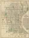
| Description: | This map shows wards, roads, railroads, parks, cemeteries, select buildings, and Lake Michigan. Also included is a street index. Cemeteries and parks are i... |

| Date: | 1920 |
|---|---|
| Description: | This map shows wards, streets, railroads, parks, cemeteries, select buildings, and Lake Michigan. Also included is a street index. Cemeteries and parks are... |

| Date: | 1910 |
|---|---|
| Description: | This ink on paper blue line print base map consists of eight separate pieces and shows city limits, The Milwaukee Electric Railroad & Light Company lines, ... |
If you didn't find the material you searched for, our Library Reference Staff can help.
Call our reference desk at 608-264-6535 or email us at: