 Filter: Categories of Wisconsin Historical Images
Filter: Subject of Cemeteries
Filter: Subject of buildings
Filter: Subject of church buildings
Filter: Categories of Wisconsin Historical Images
Filter: Subject of Cemeteries
Filter: Subject of buildings
Filter: Subject of church buildings

| Date: | 1858 |
|---|---|
| Description: | This 1858 map of Racine County, Wisconsin, shows land ownership and acreages, the township and range grid, towns, cities and villages, roads, railroads, sc... |

| Date: | 1876 |
|---|---|
| Description: | This 1876 map of Saint Croix County, Wisconsin, shows the township and range grid, sections, towns, cities and villages, land ownership and acreages, wagon... |

| Date: | 1877 |
|---|---|
| Description: | This 1877 map of Sauk County, Wisconsin, shows the township and range grid, sections, towns, cities and villages, land ownership and acreages, wagon roads,... |

| Date: | 1862 |
|---|---|
| Description: | This map shows townships and sections, landownership and acreages, roads, railroads, cemeteries, churches, schools, mills, and stone quarries. "Engraved, p... |

| Date: | 1860 |
|---|---|
| Description: | This map shows roads, railroads, rivers, townships, school houses, churches, cemeteries, and land ownership by name. Relief is shown by hachures. The map i... |

| Date: | 1874 |
|---|---|
| Description: | Birds-eye view of Appleton Wisconsin. In the foreground are people fishing, strolling, and looking over the canal towards the Fox River. Streets and buildi... |
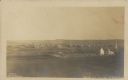
| Date: | 1910 |
|---|---|
| Description: | Text on front reads: "Bird's Eye View of Strum, Wis." Elevated view of a small town with hills on the horizon. A church and cemetery can be seen on the rig... |
If you didn't find the material you searched for, our Library Reference Staff can help.
Call our reference desk at 608-264-6535 or email us at: