 Filter: Categories of Wisconsin Historical Images
Filter: Subject of Cemeteries
Filter: Reproduction Rights of For Sale
Filter: Subject of recreation
Filter: Categories of Wisconsin Historical Images
Filter: Subject of Cemeteries
Filter: Reproduction Rights of For Sale
Filter: Subject of recreation

| Date: | 02 06 1948 |
|---|---|
| Description: | Looking southeast across Speedway Road. Visible are the reservoir on Glenway Street, Hoyt Park, Resurrection and Forest Hill cemeteries, Glenway Golf cours... |
| Date: | |
|---|---|
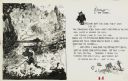
| Description: | Cartoon drawn by Clare V. "Dwig" Dwiggins depicting a youthful August Derleth walking by a graveyard that is haunted by ghosts and spirits. Derleth was fo... |
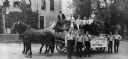
| Date: | 1914 |
|---|---|
| Description: | Boilermakers and their helpers pose on and around a horse-drawn wagon that bears a sign that reads "Boiler-makers and Helpers," perhaps for a parade. Man o... |
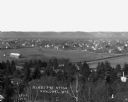
| Date: | 1915 |
|---|---|
| Description: | View of town. A cemetery is in the foreground and a race track is in the center. |
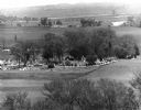
| Date: | 05 30 1967 |
|---|---|
| Description: | View of a parade traveling through a cemetery. Beyond, barns and farmhouses can be seen. |

| Date: | 01 18 1955 |
|---|---|
| Description: | Mrs. Charles Watson is shown with her rosemaled plate during the Madison Art Guild Crafts Group exchange. |

| Date: | 1946 |
|---|---|
| Description: | A map showing the roads, railroads, towns, cities and villages, streams and lakes, airports, schools, churches, cemeteries, and golf courses in Kenosha Cou... |
| Date: | 1942 |
|---|---|
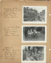
| Description: | Views of two different bike hosteling trips to Pine Bluff (Dane County) and Lake Mills (Jefferson County), sponsored by Neighborhood House, with girls rest... |

| Date: | 1942 |
|---|---|
| Description: | Four participants (Mary Lou Ciulla, Annie Gambino, Bessie Parisi, and Vita Valenza) of a bike hosteling trip sponsored by Neighborhood House, resting on a ... |

| Date: | 1916 |
|---|---|
| Description: | This Wisconsin Conservation Commission map from 1916 shows Peninsula State Park in the Town of Gibraltar, Door County, Wisconsin. Depicted are open and pla... |

| Date: | 1916 |
|---|---|
| Description: | This version of a 1916 Wisconsin Conservation Commission map shows Peninsula State Park in the Town of Gibraltar, Door County, Wisconsin. Depicted are open... |

| Date: | 1976 |
|---|---|
| Description: | Panel title. Shows railroads, roads, highways, boundaries, dams, public hunting and fishing grounds, cemeteries, forest ranger stations, plant life, and s... |

| Date: | 1955 |
|---|---|
| Description: | This map includes a street index and shows municipal golf course, parks, schools, cemeteries, Janesville County Club, and industrial sites. The back of the... |

| Date: | 1938 |
|---|---|
| Description: | This map shows plat of town, land ownership by name, city limits, section boundaries, wards, local roads, railroads, parks, fairgrounds, cemeteries, locati... |

| Date: | 1960 |
|---|---|
| Description: | This blue line print shows state and city maintained roads, as well as government land, parks, Milwaukee Co. Park Commission, golf courses, schools, City o... |

| Date: | 05 27 1964 |
|---|---|
| Description: | Two lake patrol boats ready to start their summer season patrolling of Lakes Kegonsa and Waubesa. Manning the boats are Sheriff Vernon Leslie, center and l... |

| Date: | 1936 |
|---|---|
| Description: | This map shows campsites, trails, auto roads, surrounding townships, and points of interest, by including pictorial illustrations. Includes an inserted map... |

| Date: | 1874 |
|---|---|
| Description: | Birds-eye view of Appleton Wisconsin. In the foreground are people fishing, strolling, and looking over the canal towards the Fox River. Streets and buildi... |
If you didn't find the material you searched for, our Library Reference Staff can help.
Call our reference desk at 608-264-6535 or email us at: