 Filter: Categories of Wisconsin Historical Images
Filter: Subject of Cemeteries
Filter: Creator Name of Unknown
Filter: Categories of Wisconsin Historical Images
Filter: Subject of Cemeteries
Filter: Creator Name of Unknown

| Date: | 1982 |
|---|---|
| Description: | Two men in suits are standing in a cemetery, looking at a metal grave vault. The vault is supported by two wooden beams. Caption reads: "A 12 gauge Clark m... |

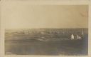
| Date: | 1888 |
|---|---|
| Description: | View towards a wooden walkway over a stone wall, perhaps a spillway, crossing a body of water. A bridge is in the background. |
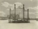
| Date: | 11 21 1931 |
|---|---|
| Description: | View of a wrought iron structure in an "island" garden in the middle of an entryway, with the Great Memorial Building in the background. |

| Date: | |
|---|---|
| Description: | View down a long dirt road. In the distance the road passes under a railroad bridge near a church with a cemetery. Caption reads: "Lover's Lane, Mapleton, ... |

| Date: | 05 1910 |
|---|---|
| Description: | Floral tributes, including wreaths and a cross, form a large display at the base of the obelisk marking the Brumder family plot in Forest Home Cemetery. O... |

| Date: | |
|---|---|
| Description: | View from shoreline towards a group of men sitting and standing on a seaplane pulled up to the shoreline. The pilot is standing in the cockpit. List of na... |

| Date: | 1887 |
|---|---|
| Description: | A plat map of Waterford. Township 4, North Range 19, East of 4th Principal Meridian. References at bottom include school houses, houses, churches and cemet... |
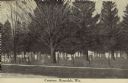
| Date: | 1907 |
|---|---|
| Description: | Text on front reads: "Cemetery, Rosendale, Wis." A cemetery inside a chain link fence with mature trees. A sidewalk runs along the unpaved road in the fore... |
| Date: | 1910 |
|---|---|
| Description: | Text on front reads: "Bird's Eye View of Strum, Wis." Elevated view of a small town with hills on the horizon. A church and cemetery can be seen on the rig... |

| Date: | 1910 |
|---|---|
| Description: | Text on front reads: "Viroqua, Wis." The driveway gate sign reads: "Viroqua Cemetery." The gate, sign and fence are painted a light color. There are many t... |

| Date: | 12 22 1906 |
|---|---|
| Description: | Text on front reads: "German Luth. Church near Whitehall, Wis." The church building on the right is surrounded by a farm, trees, fields and fences. |
| Date: | 1926 |
|---|---|
| Description: | A woman holding flowers is standing between two graves, looking at the one on the left. Caption reads: "Wind River Indian Reservation (formerly the Shosho... |

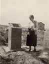
| Date: | 1914 |
|---|---|
| Description: | Pg. 44 West Half of Marion Township. Pg. 45 East Half of Marion Township. |
| Date: | 1906 |
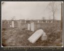
|---|---|
| Description: | View of a cemetery with several tombstones, one of which appears broken and resting against its base. A building is in the background. Caption reads: "Th... |

| Date: | |
|---|---|
| Description: | View across field towards a long, stone building. There is a small shed behind the building on the left, and a fence is on the right. A person is walking n... |

| Date: | 1910 |
|---|---|
| Description: | A land ownership map of the township of Leroy. |
If you didn't find the material you searched for, our Library Reference Staff can help.
Call our reference desk at 608-264-6535 or email us at:
