 Filter: Categories of Wisconsin Historical Images
Filter: Subject of Cemeteries
Filter: Creator Name of Unknown
Filter: Categories of Wisconsin Historical Images
Filter: Subject of Cemeteries
Filter: Creator Name of Unknown

| Date: | 1970 |
|---|---|
| Description: | This map shows lots, house numbers, institutional buildings, and cemeteries. The bottom of the map includes indexes to streets, points of interest and inst... |

| Date: | 1960 |
|---|---|
| Description: | This blue line print shows state and city maintained roads, as well as government land, parks, Milwaukee Co. Park Commission, golf courses, schools, City o... |

| Date: | 11 15 1957 |
|---|---|
| Description: | This map shows single family residence district, business district, and manufacturing district, as well as block and lot numbers, Hustis Homestead, gravel ... |

| Date: | 1965 |
|---|---|
| Description: | This map shows 32 zoning districts, house numbering system, parks, cemeteries, and Milwaukee County institutional buildings. |

| Date: | 1910 |
|---|---|
| Description: | This ink on paper blue line print base map consists of eight separate pieces and shows city limits, The Milwaukee Electric Railroad & Light Company lines, ... |

| Date: | 1924 |
|---|---|
| Description: | This map shows streets, selected buildings, railroads, railway yards, schools, parks, schools, cemeteries, bays, the Milwaukee River, and Lake Michigan. De... |

| Date: | 1894 |
|---|---|
| Description: | This map shows sewers, intercepting sewers, manholes, block numbers, streets, railroads, parks, cemeteries, and Lake Michigan. The right margin reads: "Tot... |

| Date: | 1879 |
|---|---|
| Description: | This map shows asylums, cemeteries, hospitals, parks, streets, and wards. Relief is shown by contours. Also included are manuscript annotations in pencil. ... |
| Date: | |
|---|---|
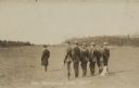
| Description: | Three-quarter view from rear of group of men standing in a field. Governor James O. Davidson stands in front of the group on the left. Behind him six men i... |

| Date: | 1936 |
|---|---|
| Description: | This map shows campsites, trails, auto roads, surrounding townships, and points of interest, by including pictorial illustrations. Includes an inserted map... |

| Date: | 1896 |
|---|---|
| Description: | This map shows railroads, churches, schools, cemeteries, rivers, lakes, and some rural property owners. |
| Date: | 1915 |
|---|---|
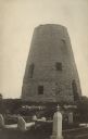
| Description: | Photographic postcard view of the old grist mill, with a cemetery in the foreground. Caption reads: "The Old Mill, Cedarburg." |

| Date: | 1789 |
|---|---|
| Description: | Map of New York City showing ward boundaries, ferries, streets, roads, swamps, ponds, and rivers. The properties of Lispinard, Byards, Jones, Rutgers, and ... |

| Date: | 02 01 1919 |
|---|---|
| Description: | Hundreds of graves for fallen soldiers at Dead Man's Hill. Captioned: "Cemetery at foot of Mort Homme (Dead Man's Hill). Notice the 'communication trenches... |

| Date: | 02 01 1919 |
|---|---|
| Description: | A cross marking the grave of a German soldier. Other graves are in the background. Captioned: "A 'Fritz'." |
| Date: | |
|---|---|
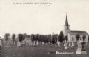
| Description: | The Evangelical Lutheran Church with a cemetery in the churchyard. Caption reads: "Ev. Luth. Church at Hope, Dane Co., Wis." Also known as Hope Lutheran C... |

| Date: | |
|---|---|
| Description: | Exterior of a small church, with a cemetery in the foreground. Caption reads: "St. John's Evangelical Lutheran Church. Built 1864, Town of Dane, Dane Count... |
| Date: | 1911 |
|---|---|
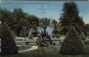
| Description: | Hand-colored view of a fountain obscured by a flowering bush. Caption reads: "Fountain in Oak Grove Cemetery, La Crosse, Wis." |
| Date: | |
|---|---|
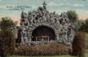
| Description: | Hand-colored view of the grotto in the Catholic Cemetery. Caption reads: "Grotto — Catholic Cemetery, La Crosse, Wis." |
If you didn't find the material you searched for, our Library Reference Staff can help.
Call our reference desk at 608-264-6535 or email us at:
