 Filter: Categories of Wisconsin Historical Images
Filter: Subject of Caves
Filter: Reproduction Rights of For Sale
Filter: Categories of Wisconsin Historical Images
Filter: Subject of Caves
Filter: Reproduction Rights of For Sale

| Date: | |
|---|---|
| Description: | Photographic postcard view of the stairs leading to the exit of Cave of the Mounds. |
| Date: | |
|---|---|
| Description: | Photographic postcard view down a path past stalagmites. |

| Date: | |
|---|---|
| Description: | Photographic postcard view of a stalagmite surrounded by smaller stalagmites. |

| Date: | |
|---|---|
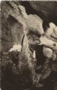
| Description: | Photographic postcard view of interior of cave with large stalagmites and dozens of stalactites. |

| Date: | |
|---|---|
| Description: | Stalactite-rich rooms of the Cave of the Mounds. |

| Date: | |
|---|---|
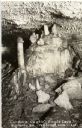
| Description: | Photographic postcard view of a stalactite connected to stalagmites on the floor. Smaller stalactites surround it. |
| Date: | |
|---|---|
| Description: | Postcard view of rock structure known as Cordova Castle in Eagle Cave. Caption reads: "'Cordova Castle,' Eagle Cave, Highway 60, Muscoda, Wis." |
| Date: | 1914 |
|---|---|
| Description: | Postcard for Marquette Park in Grant County, number 4706 in a series by E.A. Bishop of Racine. The caption on the back of the postcard reads: "The pictures... |
| Date: | 1910 |
|---|---|
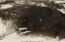
| Description: | Sunlit opening of a large carved out man-made cave with a park bench in the foreground in Irvine Park. The figure of a woman in the cave is obscured by sha... |

| Date: | |
|---|---|
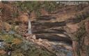
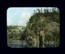
| Description: | View across lake towards steep bluffs. Trees are growing along the shoreline and on the top of the bluffs. At the base of the cliffs in the center is a sca... |

| Date: | |
|---|---|
| Description: | View across water towards trees growing on the steep cliffs of a bluff at the shoreline. There is a cave about halfway up the cliff. |

| Date: | |
|---|---|
| Description: | View across a river towards rock formations on the far shoreline. Several people are standing in a boat or canoe in a cave on the right. |
| Date: | |
|---|---|
| Description: | View across water towards people in an excursion boat on a river passing rocky and hilly shoreline covered with trees and plants. There is a man in another... |
| Date: | 07 1929 |
|---|---|
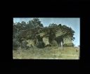
| Description: | View uphill towards the entrance to the McSherry Cave. A woman is standing at the entrance. Trees and shrubs are growing on top of the cave. |

| Date: | |
|---|---|
| Description: | View along side of cliff towards a rock formation, with what may be a cave inside the rock. |
| Date: | 11 01 1955 |
|---|---|
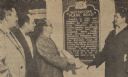
| Description: | President of the Miller Brewing Company, Norman R. Klug, unveiled the Watertown Plank Road historical marker along with, to his left, James Fitzpatrick, pr... |

| Date: | 11 01 1955 |
|---|---|
| Description: | Raymond Sivesind, director of the sites and markers program of the State Historical Society, as a speaker in the dedication and unveiling ceremony, stands ... |
| Date: | 1958 |
|---|---|
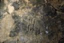
| Description: | Carving in stone of a human fugure at Gullickson's Glen. |

| Date: | 1791 |
|---|---|
| Description: | Small map of an abandoned Native American town and fort at the junction of the Ohio and Muskingum River. It shows the fortifications, an outline of the tow... |

| Date: | 1907 |
|---|---|
| Description: | View of Monterey Rock from the Rock River. There is a cave in the center, and a bridge in the distance. |
If you didn't find the material you searched for, our Library Reference Staff can help.
Call our reference desk at 608-264-6535 or email us at: