 Filter: Categories of Wisconsin Historical Images
Filter: Subject of Capitols
Filter: Categories of Wisconsin Historical Images
Filter: Subject of Capitols

| Date: | 1930 |
|---|---|
| Description: | This map shows the western side of Madison, from Nakoma to the capitol. The map is oriented with north to upper right and the scale is indicated by quarter... |

| Date: | 1836 |
|---|---|
| Description: | This map show plat of the city, local streets, block numbers, section lines, and canals. The map includes reference text: "Surveyor's office, Brown County ... |

| Date: | 1855 |
|---|---|
| Description: | This map shows a plat of the city, local streets, numbered blocks and lots, university grounds, the Capitol Square, and parts of Third and Fourth Lakes (La... |

| Date: | 1889 |
|---|---|
| Description: | This map shows a plat of city, city limits, numbered blocks, numbered lots, wards, local streets, roads, railroads, street railways, fire limits, hydrants,... |

| Date: | 1896 |
|---|---|
| Description: | This map shows a plat of the town, wards, buildings, the state capitol, local streets, railroads, and parts of Lake Mendota, Lake Monona, and Lake Wingra. ... |
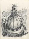
| Date: | |
|---|---|
| Description: | Drawing of the Wisconsin State Capitol building. Features the dome with the "Wisconsin" statue replaced by a seated beekeeper wearing protective clothing, ... |
| Date: | 1923 |
|---|---|
| Description: | This map shows local streets, parks, Lake Wingra, and parts of Lake Mendota and Lake Monona. The map includes a legend showing residential, commercial, lig... |

| Date: | 1926 |
|---|---|
| Description: | This map is oriented with the north to the upper right and shows a plat of the area, numbered blocks, lots, and wards, land ownership by name, local street... |

| Date: | |
|---|---|
| Description: | Congressman David Obey and his son Craig pose for a photo in the nation's Capitol. A line of people appear in the background. |

| Date: | |
|---|---|
| Description: | Congressman David R. Obey and Senator William Proxmire outside the Capitol building in Washington, D.C. |

| Date: | |
|---|---|
| Description: | Detail from a drawing of a plan for the isthmus. |

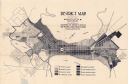
| Date: | 1906 |
|---|---|
| Description: | This map shows shows streets, subdivisions, railroads, places of interest including the State Capitol, the University of Wisconsin, Camp Randall, Henry Vil... |

| Date: | 1924 |
|---|---|
| Description: | Intended for tourists, this brochure, titled: "Plan Now to See Madison, The Four Lake City: "The City Built on an Isthmus," features a map of Madison and s... |

| Date: | 1921 |
|---|---|
| Description: | This map has labeled streets and points of interest. Lake Mendota and Lake Monona are labeled. The back of the map includes index of University of Wisconsi... |

| Date: | 1950 |
|---|---|
| Description: | View from street towards the United States Capitol building. Several buses drive along the street with parked cars in a parking lot on the left. |
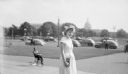
| Date: | 1950 |
|---|---|
| Description: | Shirley Krueger posing on stairs near a street, with the United States Capitol Building in the distant background. A child is riding a tricycle on the side... |

| Date: | 1929 |
|---|---|
| Description: | This map includes illustrations and shows campus buildings, points of interest in the surrounding area, railroads, Lake Mendota and Lake Monona. The back o... |

| Date: | 1914 |
|---|---|
| Description: | This map shows plat of the town, city limits, numbered blocks and lots, wards, local streets, roads, railroads, Capitol Square, Vilas Park, Edgewood Academ... |

| Date: | 1914 |
|---|---|
| Description: | This map shows a plat of the town, city limits, numbered blocks and lots, wards, local streets, roads, railroads, Capitol Square, Vilas Park, Edgewood Acad... |

| Date: | 1938 |
|---|---|
| Description: | This map is blue line print and shows local streets, roads, the University of Wisconsin, Monona Village, Verona, Middleton, McFarland, Lake Mendota, Lake M... |
If you didn't find the material you searched for, our Library Reference Staff can help.
Call our reference desk at 608-264-6535 or email us at: