 Filter: Categories of Wisconsin Historical Images
Filter: Subject of Capitols
Filter: Year of 1900-1999
Filter: Year of 1930-1939
Filter: Categories of Wisconsin Historical Images
Filter: Subject of Capitols
Filter: Year of 1900-1999
Filter: Year of 1930-1939
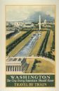
| Date: | 1934 |
|---|---|
| Description: | An original lithograph promoting Washington, D.C. as "the city that every American should know," and to get there by way of train travel. The poster depict... |

| Date: | 1932 |
|---|---|
| Description: | An original lithograph promoting Washington, D.C., and the Pennsylvania Railroad through artist N.C. Wyeth's depiction of the 1798 construction of the firs... |

| Date: | 1937 |
|---|---|
| Description: | A man wearing a hat and tie is driving an International I-12 industrial tractor with mower attachment to groom the grounds in front of the Arkansas state c... |

| Date: | 1934 |
|---|---|
| Description: | This map includes a street index. The map is oriented with the north toward the upper right. Includes handwritten annotations of the 1935 bus routes. |

| Date: | 1930 |
|---|---|
| Description: | Indexed map of Madison. Streets, lakes, and points of interest are labelled. Around the edges of the map are the indexed street names. |

| Date: | 1930 |
|---|---|
| Description: | This map features a legend of highways, railroads, parks, and service stations. The cover and inside of the map features pictures of attractions in Madison... |

| Date: | 1930 |
|---|---|
| Description: | This map of Madison is 7 maps showing the city between 1885 and 1930. Each map has its own annotations of population growth, neighborhoods, and other cha... |

| Date: | 1930 |
|---|---|
| Description: | This map shows the western side of Madison, from Nakoma to the capitol. The map is oriented with north to upper right and the scale is indicated by quarter... |

| Date: | 1938 |
|---|---|
| Description: | This map is blue line print and shows local streets, roads, the University of Wisconsin, Monona Village, Verona, Middleton, McFarland, Lake Mendota, Lake M... |
If you didn't find the material you searched for, our Library Reference Staff can help.
Call our reference desk at 608-264-6535 or email us at: