 Filter: Categories of Wisconsin Historical Images
Filter: Subject of Capitols
Filter: Year of 1900-1999
Filter: Year of 1920-1929
Filter: Categories of Wisconsin Historical Images
Filter: Subject of Capitols
Filter: Year of 1900-1999
Filter: Year of 1920-1929

| Date: | 1920 |
|---|---|
| Description: | A map of Madison and the vicinity. Red lines show the street railway. |
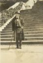
| Date: | 1926 |
|---|---|
| Description: | Full-length portrait of Frank Lloyd Wright standing at the foot of the steps of the national Capitol. |

| Date: | 1920 |
|---|---|
| Description: | Shows wards and selected points of interest. Includes street index. Oriented with north to upper right. |

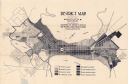
| Date: | 1927 |
|---|---|
| Description: | Map reads: "Now You Can Visualize Madison". Includes indexes, with points marked 1-98 and a key. Text and illustrations on verso include hotels and seasona... |

| Date: | 1925 |
|---|---|
| Description: | This map shows the public schools and their school districts. The bottom of the map reads:" Old buildings and sites in red. New buildings and sites in blac... |
| Date: | 1923 |
|---|---|
| Description: | This map shows local streets, parks, Lake Wingra, and parts of Lake Mendota and Lake Monona. The map includes a legend showing residential, commercial, lig... |

| Date: | 1926 |
|---|---|
| Description: | This map is oriented with the north to the upper right and shows a plat of the area, numbered blocks, lots, and wards, land ownership by name, local street... |

| Date: | 1924 |
|---|---|
| Description: | Intended for tourists, this brochure, titled: "Plan Now to See Madison, The Four Lake City: "The City Built on an Isthmus," features a map of Madison and s... |

| Date: | 1921 |
|---|---|
| Description: | This map has labeled streets and points of interest. Lake Mendota and Lake Monona are labeled. The back of the map includes index of University of Wisconsi... |

| Date: | 1929 |
|---|---|
| Description: | This map includes illustrations and shows campus buildings, points of interest in the surrounding area, railroads, Lake Mendota and Lake Monona. The back o... |
If you didn't find the material you searched for, our Library Reference Staff can help.
Call our reference desk at 608-264-6535 or email us at: