 Filter: Categories of Wisconsin Historical Images
Filter: Subject of Capitols
Filter: Year of 1900-1999
Filter: Year of 1910-1919
Filter: Categories of Wisconsin Historical Images
Filter: Subject of Capitols
Filter: Year of 1900-1999
Filter: Year of 1910-1919
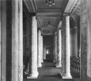
| Date: | 1917 |
|---|---|
| Description: | A view down the corridor of the fourth Wisconsin State Capitol. |
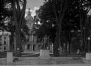
| Date: | 1915 |
|---|---|
| Description: | A statue of Franklin Pierce in a park plaza surrounded by trees. The capitol building surmounted by the original war eagle statue fills the background. |

| Date: | 1913 |
|---|---|
| Description: | This map shows city wards and government buildings. The map is oriented with north to upper right. |

| Date: | 1918 |
|---|---|
| Description: | This map shows Madison and includes an index of University of Wisconsin buildings, city buildings, and churches. Lake Mendota, Lake Monona, and Lake Wingra... |

| Date: | 1914 |
|---|---|
| Description: | This map shows plat of the town, city limits, numbered blocks and lots, wards, local streets, roads, railroads, Capitol Square, Vilas Park, Edgewood Academ... |

| Date: | 1914 |
|---|---|
| Description: | This map shows a plat of the town, city limits, numbered blocks and lots, wards, local streets, roads, railroads, Capitol Square, Vilas Park, Edgewood Acad... |
If you didn't find the material you searched for, our Library Reference Staff can help.
Call our reference desk at 608-264-6535 or email us at:
