 Filter: Categories of Wisconsin Historical Images
Filter: Subject of Capitols
Filter: Year of 1900-1999
Filter: Categories of Wisconsin Historical Images
Filter: Subject of Capitols
Filter: Year of 1900-1999

| Date: | 1954 |
|---|---|
| Description: | Wisconsin State Capitol rotunda during the holiday season. A man is standing on a ladder which is on top of scaffolding to decorate the tree. |
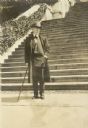
| Date: | 1926 |
|---|---|
| Description: | Full-length portrait of Frank Lloyd Wright standing at the foot of the steps of the national Capitol. |
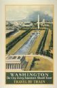
| Date: | 1934 |
|---|---|
| Description: | An original lithograph promoting Washington, D.C. as "the city that every American should know," and to get there by way of train travel. The poster depict... |
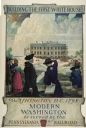
| Date: | 1932 |
|---|---|
| Description: | An original lithograph promoting Washington, D.C., and the Pennsylvania Railroad through artist N.C. Wyeth's depiction of the 1798 construction of the firs... |
| Date: | 1915 |
|---|---|
| Description: | A statue of Franklin Pierce in a park plaza surrounded by trees. The capitol building surmounted by the original war eagle statue fills the background. |

| Date: | 1937 |
|---|---|
| Description: | A man wearing a hat and tie is driving an International I-12 industrial tractor with mower attachment to groom the grounds in front of the Arkansas state c... |

| Date: | 1913 |
|---|---|
| Description: | This map shows city wards and government buildings. The map is oriented with north to upper right. |

| Date: | 1934 |
|---|---|
| Description: | This map includes a street index. The map is oriented with the north toward the upper right. Includes handwritten annotations of the 1935 bus routes. |

| Date: | 1940 |
|---|---|
| Description: | Shows property ownership, store divisions, and bus stops. "Sept. 12, 1940." Oriented with north to the right. Insets: "Trade area" location map and enlarge... |

| Date: | 1930 |
|---|---|
| Description: | Indexed map of Madison. Streets, lakes, and points of interest are labelled. Around the edges of the map are the indexed street names. |

| Date: | 1943 |
|---|---|
| Description: | Shows Madison city limits with thick solid lines and ward districts with dotted lines. The wards are numbered, and points of interests and land marks are l... |

| Date: | 1948 |
|---|---|
| Description: | Map created between 1948 and 1954. Shows businesses and lot owners around the State Capitol. Oriented with north to the upper right. Includes "continued in... |

| Date: | 1961 |
|---|---|
| Description: | Shows wards and voting precincts. Published in The Capital times: January 28, 1961. |

| Date: | 1964 |
|---|---|
| Description: | Indexed map. Street names are to the left, map is to the right. Lakes, streets, highways, and points of interest are labelled. |

| Date: | 1978 |
|---|---|
| Description: | Bird’s-eye view map. Shows Madison from the edge of Lake Monona stretching west. Above the map are clouds and in the distance is the edge of the world and ... |

| Date: | 1904 |
|---|---|
| Description: | This map shows numbered wards and plots, labelled streets, and parks in green. |

| Date: | 1907 |
|---|---|
| Description: | Shows public buildings, hotels, fraternity houses, and private houses. Index of fraternities and sororities, residences, public buildings, hotels, places o... |

| Date: | 1908 |
|---|---|
| Description: | Shows pipes of various sizes, hydrants, valves, and wells. "1907" -- Lower margin. Lake Wingra, Lake Monona, and Lake Mendota are labelled. |

| Date: | 1909 |
|---|---|
| Description: | Streets, Lake Wingra, Lake Mendota, and Lake Monona are all labelled. Map reads: "The present park system of Madison comprises 150 acres of improved parks,... |

| Date: | 1920 |
|---|---|
| Description: | Shows wards and selected points of interest. Includes street index. Oriented with north to upper right. |
If you didn't find the material you searched for, our Library Reference Staff can help.
Call our reference desk at 608-264-6535 or email us at: