 Filter: Categories of Wisconsin Historical Images
Filter: Subject of Capitols
Filter: Year of 1800-1899
Filter: Year of 1850-1859
Filter: Categories of Wisconsin Historical Images
Filter: Subject of Capitols
Filter: Year of 1800-1899
Filter: Year of 1850-1859
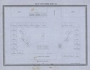
| Date: | 1855 |
|---|---|
| Description: | Plan of the Senate Chamber for the second Wisconsin State Capitol (the first in Madison), showing the seating arrangement. |

| Date: | 1853 |
|---|---|
| Description: | Wisconsin counties by color and shows railroads, common roads, canals, the state capital, county towns, townships, villages, and post offices, |

| Date: | 1854 |
|---|---|
| Description: | Map of the whole state Wisconsin includes an inset of the vicinity of Milwaukee, which shows the boundaries for Lisbon, Menomonee, Pewaukee, Brookfield, Wa... |

| Date: | 1851 |
|---|---|
| Description: | This map shows plats with lots and block numbers of Madison. The far left corner features "University Ground" and some streets are labeled. Lake Monona is ... |

| Date: | 1855 |
|---|---|
| Description: | This bird's-eye-view map of Madison is looking north across Lake Monona. The map features two women and two men on a lookout on top of a building in the fo... |

| Date: | 1855 |
|---|---|
| Description: | This map shows a plat of the city, local streets, numbered blocks and lots, university grounds, the Capitol Square, and parts of Third and Fourth Lakes (La... |
If you didn't find the material you searched for, our Library Reference Staff can help.
Call our reference desk at 608-264-6535 or email us at: