 Filter: Categories of Wisconsin Historical Images
Filter: Subject of Capitols
Filter: Subject of human settlements
Filter: Subject of learning and scholarship
Filter: Categories of Wisconsin Historical Images
Filter: Subject of Capitols
Filter: Subject of human settlements
Filter: Subject of learning and scholarship
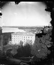
| Date: | 1876 |
|---|---|
| Description: | View from Main Hall (later Bascom Hall) on the University of Wisconsin campus. North Hall is in the foreground. Behind it is Langdon Street and, in the d... |
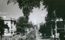
| Date: | 1971 |
|---|---|
| Description: | View of State Street looking east towards the Wisconsin State Capitol from Bascom Hill (on the University of Wisconsin-Madison campus). The Wisconsin Histo... |

| Date: | 1918 |
|---|---|
| Description: | This map shows Madison and includes an index of University of Wisconsin buildings, city buildings, and churches. Lake Mendota, Lake Monona, and Lake Wingra... |

| Date: | 1855 |
|---|---|
| Description: | This map shows a plat of the city, local streets, numbered blocks and lots, university grounds, the Capitol Square, and parts of Third and Fourth Lakes (La... |

| Date: | 1924 |
|---|---|
| Description: | Intended for tourists, this brochure, titled: "Plan Now to See Madison, The Four Lake City: "The City Built on an Isthmus," features a map of Madison and s... |

| Date: | 1914 |
|---|---|
| Description: | This map shows plat of the town, city limits, numbered blocks and lots, wards, local streets, roads, railroads, Capitol Square, Vilas Park, Edgewood Academ... |
If you didn't find the material you searched for, our Library Reference Staff can help.
Call our reference desk at 608-264-6535 or email us at: