 Filter: Categories of Wisconsin Historical Images
Filter: Subject of Capitols
Filter: Subject of cities and towns
Filter: Subject of central business districts
Filter: Categories of Wisconsin Historical Images
Filter: Subject of Capitols
Filter: Subject of cities and towns
Filter: Subject of central business districts
| Date: | 1971 |
|---|---|
| Description: | View of State Street looking east towards the Wisconsin State Capitol from Bascom Hill (on the University of Wisconsin-Madison campus). The Wisconsin Histo... |

| Date: | |
|---|---|
| Description: | Elevated view, probably taken from the old Wisconsin State Capitol building, looking down East Washington Avenue toward the water tower. |

| Date: | |
|---|---|
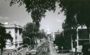
| Description: | Elevated view, probably from the old Wisconsin State Capitol building, looking west down State Street. |

| Date: | 1940 |
|---|---|
| Description: | Shows property ownership, store divisions, and bus stops. "Sept. 12, 1940." Oriented with north to the right. Insets: "Trade area" location map and enlarge... |

| Date: | 1948 |
|---|---|
| Description: | Map created between 1948 and 1954. Shows businesses and lot owners around the State Capitol. Oriented with north to the upper right. Includes "continued in... |

| Date: | 1908 |
|---|---|
| Description: | A Sanborn map featuring the Capitol Square and surrounding business district. |
| Date: | |
|---|---|
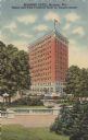
| Description: | View from Capitol grounds towards the hotel on the corner of N. Pinckney Street and E. Mifflin Street. Caption reads: "Belmont Hotel,Madison, Wis. Tallest ... |

| Date: | 11 23 1957 |
|---|---|
| Description: | City workers install holiday decorations and lights on light poles on the corner of South Carroll and W. Main Streets at the Capitol Square. A man is seen ... |
If you didn't find the material you searched for, our Library Reference Staff can help.
Call our reference desk at 608-264-6535 or email us at: