 Filter: Categories of Wisconsin Historical Images
Filter: Subject of Capitols
Filter: Subject of buses
Filter: Categories of Wisconsin Historical Images
Filter: Subject of Capitols
Filter: Subject of buses

| Date: | 1934 |
|---|---|
| Description: | This map includes a street index. The map is oriented with the north toward the upper right. Includes handwritten annotations of the 1935 bus routes. |
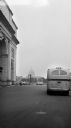
| Date: | 1950 |
|---|---|
| Description: | View from street towards the United States Capitol building. Several buses drive along the street with parked cars in a parking lot on the left. |
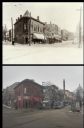
| Date: | |
|---|---|
| Description: | A vintage view and a modern view of the 200 block of State Street, presented as a pair. The vintage view shows Tailors and Gents Furnishers, John Ripp's Gr... |
If you didn't find the material you searched for, our Library Reference Staff can help.
Call our reference desk at 608-264-6535 or email us at: