 Filter: Categories of Wisconsin Historical Images
Filter: Subject of Capitols
Filter: County of Dane
Filter: Categories of Wisconsin Historical Images
Filter: Subject of Capitols
Filter: County of Dane
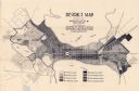
| Date: | 1923 |
|---|---|
| Description: | This map shows local streets, parks, Lake Wingra, and parts of Lake Mendota and Lake Monona. The map includes a legend showing residential, commercial, lig... |

| Date: | 1926 |
|---|---|
| Description: | This map is oriented with the north to the upper right and shows a plat of the area, numbered blocks, lots, and wards, land ownership by name, local street... |

| Date: | |
|---|---|
| Description: | Detail from a drawing of a plan for the isthmus. |

| Date: | 1906 |
|---|---|
| Description: | This map shows shows streets, subdivisions, railroads, places of interest including the State Capitol, the University of Wisconsin, Camp Randall, Henry Vil... |

| Date: | 1924 |
|---|---|
| Description: | Intended for tourists, this brochure, titled: "Plan Now to See Madison, The Four Lake City: "The City Built on an Isthmus," features a map of Madison and s... |

| Date: | 1921 |
|---|---|
| Description: | This map has labeled streets and points of interest. Lake Mendota and Lake Monona are labeled. The back of the map includes index of University of Wisconsi... |

| Date: | 1929 |
|---|---|
| Description: | This map includes illustrations and shows campus buildings, points of interest in the surrounding area, railroads, Lake Mendota and Lake Monona. The back o... |

| Date: | 1914 |
|---|---|
| Description: | This map shows plat of the town, city limits, numbered blocks and lots, wards, local streets, roads, railroads, Capitol Square, Vilas Park, Edgewood Academ... |

| Date: | 1914 |
|---|---|
| Description: | This map shows a plat of the town, city limits, numbered blocks and lots, wards, local streets, roads, railroads, Capitol Square, Vilas Park, Edgewood Acad... |

| Date: | 1938 |
|---|---|
| Description: | This map is blue line print and shows local streets, roads, the University of Wisconsin, Monona Village, Verona, Middleton, McFarland, Lake Mendota, Lake M... |

| Date: | 1960 |
|---|---|
| Description: | This map shows block numbers, tract numbers, tract boundaries, city limits, local streets, railroads, Lake Mendota, and Lake Monona. |

| Date: | 05 09 1964 |
|---|---|
| Description: | Navy servicemen parade around the Capitol Square in observance of Armed Forces Day in Madison. The theme of the day-long event held at Truax Field is "Powe... |

| Date: | 1968 |
|---|---|
| Description: | This blue line print map shows proposed changes reserving railroad right-of-ways for future highways, land plots, as well as Lake Monona and Lake Mendota. |
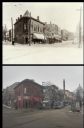
| Date: | |
|---|---|
| Description: | A vintage view and a modern view of the 200 block of State Street, presented as a pair. The vintage view shows Tailors and Gents Furnishers, John Ripp's Gr... |
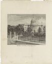
| Date: | 1878 |
|---|---|
| Description: | This frontispiece lithograph shows the State Capitol with an American flag on flying on top of the dome. The grounds include trees and paths and are enclos... |

| Date: | 1908 |
|---|---|
| Description: | A Sanborn map featuring the Capitol Square and surrounding business district. |
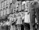
| Date: | 05 31 1954 |
|---|---|
| Description: | Children lining the street for the Memorial Day parade around Capitol Square. |
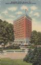
| Date: | |
|---|---|
| Description: | View from Capitol grounds towards the hotel on the corner of N. Pinckney Street and E. Mifflin Street. Caption reads: "Belmont Hotel,Madison, Wis. Tallest ... |
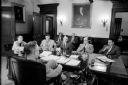
| Date: | 04 22 1957 |
|---|---|
| Description: | Wisconsin Governor Vernon W. Thomson sits at his desk during a press conference. Newsmen seated around the governor's desk are (from the left): Mack Hoffma... |

| Date: | 11 23 1957 |
|---|---|
| Description: | City workers install holiday decorations and lights on light poles on the corner of South Carroll and W. Main Streets at the Capitol Square. A man is seen ... |
If you didn't find the material you searched for, our Library Reference Staff can help.
Call our reference desk at 608-264-6535 or email us at: