 Filter: Categories of Wisconsin Historical Images
Filter: Subject of Capitol buildings
Filter: Year of 1900-1999
Filter: Type of Map or Atlas
Filter: Categories of Wisconsin Historical Images
Filter: Subject of Capitol buildings
Filter: Year of 1900-1999
Filter: Type of Map or Atlas

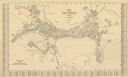
| Date: | 1908 |
|---|---|
| Description: | Colored map showing a panoramic view of Madison in great detail. The Wisconsin State Capitol is located at the center, with Lake Mendota in the background ... |
| Date: | 1930 |
|---|---|
| Description: | This map is indexed with the north oriented toward the upper right. The map includes a collection manuscript annotations. |

| Date: | 1929 |
|---|---|
| Description: | This is a blue line print map that shows local streets, railroads, local businesses, schools, parks, cemeteries, the airport, the state capitol, the Univer... |

| Date: | 1937 |
|---|---|
| Description: | Pictorial map showing historical events and locations within the state of Wisconsin, as well as waterways and counties. Original caption on the bottom marg... |

| Date: | 1970 |
|---|---|
| Description: | This photocopy map shows the locations of historic buildings, as well as all other buildings in the isthmus. The map also includes photographs of selected ... |
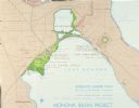
| Date: | 1967 |
|---|---|
| Description: | Schematic Master Plan for the City of Madison, Wisconsin. William Wesley Peters, Architect • The Frank Lloyd Wright Foundation. |
If you didn't find the material you searched for, our Library Reference Staff can help.
Call our reference desk at 608-264-6535 or email us at: