 Filter: Categories of Wisconsin Historical Images
Filter: Subject of Canals
Filter: Categories of Wisconsin Historical Images
Filter: Subject of Canals

| Date: | 1900 |
|---|---|
| Description: | This map shows a paper city located on Swan Lake in Columbia County. It includes lot and block numbers, two public squares, and two little lakes of "good w... |

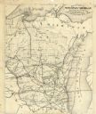
| Date: | 1857 |
|---|---|
| Description: | This map shows the railroad routes of the Milwaukee & Horicon Railroad, common roads, counties, canals, townships, cities, county towns, villages, post off... |
| Date: | 1878 |
|---|---|
| Description: | This map shows the advantages of the Sturgeon Bay and Lake Michigan Ship Canal, railroads, steamship lines across Lake Michigan, and Wisconsin township gri... |

| Date: | 1850 |
|---|---|
| Description: | This map shows the location of planned blocks and lot numbers, street names, and docks along the Fox River and canal. |
| Date: | 1897 |
|---|---|
| Description: | This map shows the distances along Fox River, as well as adjacent lakes and railroads, between Green Bay and the Wisconsin River. Lake Michigan is on the f... |

| Date: | 1896 |
|---|---|
| Description: | Front cover and interior of banquet menu for Mexican President Porfirio Diaz, to celebrate the construction of a drainage canal between Lake Texcoco and La... |

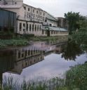
| Date: | 1920 |
|---|---|
| Description: | View across water towards factory buildings on the opposite shoreline. A two-decker boat with the name "Harvester" is moored at the dock. A large smokestac... |
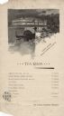
| Date: | 1893 |
|---|---|
| Description: | One-page tea room menu from the Woman's Building at the World's Columbian Exposition. At the top is an illustration of a gondolier steering a couple in a c... |

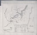
| Date: | 1868 |
|---|---|
| Description: | This map includes a table of estimated costs "by Brev. Maj. Gen. G.K. Warren Maj. U.S.E., of improvement of Wis. River from his survey of 1867." Included a... |

| Date: | 2000 |
|---|---|
| Description: | This map shows the industrial area along the Menominee River and canals. Industrial buildings are shown in orange and labeled in red. Other areas are shown... |

| Date: | 1790 |
|---|---|
| Description: | This map of the north eastern states shows roads, rivers, lakes, waterfalls, mountains, cities, forts, mills, the Oneida Reservation, and "New York Donatio... |

| Date: | 1920 |
|---|---|
| Description: | Aerial view across water towards McCormick Works. Railroad cars are on railroad tracks along the shoreline. |

| Date: | |
|---|---|
| Description: | View from shoreline towards McCormick Works buildings and railroad cars along the water. |

| Date: | 1793 |
|---|---|
| Description: | Detailed topographical map of the Ohio River between Clarkville and Louisville. It shows plots of farmland, forest, islands, garden plots, houses, Fort Fe... |

| Date: | 1874 |
|---|---|
| Description: | Birds-eye view of Appleton Wisconsin. In the foreground are people fishing, strolling, and looking over the canal towards the Fox River. Streets and buildi... |

| Date: | 1945 |
|---|---|
| Description: | John MacVane (left) standing and talking with another man on the deck of the "USS Missouri" in the Panama Canal. |

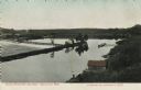
| Date: | 1886 |
|---|---|
| Description: | View across water towards the George Whiting Paper Mill on the Lawson Canal. |
| Date: | 07 1966 |
|---|---|
| Description: | View across canal towards the back of the Portage Hosiery. Reeds and trees are along the edge of the canal. Red and pink colored liquid is floating on the ... |
| Date: | |
|---|---|
| Description: | Elevated view of a canal, reservoir and dam on the Fox River. Two men are standing near a boathouse. Caption reads: "Canal Entrance and Dam, Kaukauna, Wis.... |

| Date: | |
|---|---|
| Description: | View of a lock on the Fox River. There is a boat in the canal, and pedestrians standing on the canal wall on the right. Caption reads: "Second Lock, Kaukau... |
If you didn't find the material you searched for, our Library Reference Staff can help.
Call our reference desk at 608-264-6535 or email us at: