 Filter: Categories of Wisconsin Historical Images
Filter: Subject of Canals
Filter: Year of 1900-1999
Filter: Categories of Wisconsin Historical Images
Filter: Subject of Canals
Filter: Year of 1900-1999

| Date: | 1918 |
|---|---|
| Description: | This 1918 map of Chippewa County, Wisconsin, shows the township and range grid, towns, sections, cities and villages, rural residences, churches, schools, ... |

| Date: | 1951 |
|---|---|
| Description: | Water depths shown by bathymetric tints, isolines, and soundings. Relief shown by contours. "Soundings in feet." "Aids to navigation corrected to May 4, 19... |

| Date: | 1951 |
|---|---|
| Description: | Water depths shown by bathymetric tints and soundings. Relief shown by contours. "Depths in feet." "Aids to navigation corrected to May 4, 1951." On verso:... |
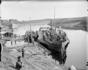
| Date: | 1918 |
|---|---|
| Description: | View looking down towards shoreline of troops on board a paddle boat on a canal. The boat flies an American flag. Other people stand on the shoreline and o... |

| Date: | 1950 |
|---|---|
| Description: | This map of Sturgeon Bay is part of the survey of the northern and northwestern lakes. The map shows lights, railroads, roads, and some public buildings. R... |

| Date: | 1951 |
|---|---|
| Description: | This map shows Ashland and Washburn harbors in shades of blue and yellow. Water depths shown by isolines and soundings, and relief is shown by contours. Th... |

| Date: | 1936 |
|---|---|
| Description: | Street map of the City of Milwaukee and surrounding suburbs indicating various mass transit lines. There is an index to Milwaukee streets at the right of t... |
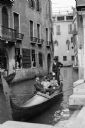
| Date: | 1906 |
|---|---|
| Description: | Mary E. Smith, seated on the right, riding a gondola ride with two friends in Venice, Italy. |

| Date: | 03 24 1950 |
|---|---|
| Description: | Front cover of a farewell dinner menu from the Italian Line ship Saturnia, with two Commedia dell' Arte characters: Pantalone, a black masked figure... |

| Date: | 1907 |
|---|---|
| Description: | A steam dredge at the construction site of a dam on a river. Identified as the construction of a canal at the Hatfield dam construction in 1907. |

| Date: | 1910 |
|---|---|
| Description: | Color enhanced view of the Fox River. Caption reads: "River Scene, De Pere, Wis." |

| Date: | 1966 |
|---|---|
| Description: | A colored map depiction of Door County, Wisconsin, with pictorial highlights, titled: "Door County — Wisconsin's Air Conditioned Peninsula Playground." |

| Date: | 06 25 1901 |
|---|---|
| Description: | This map shows beacons, buoys, docks, quarries, streets, and buildings. The map inset shows the Harbor of refuge at entrance to Sturgeon Bay and Lake Michi... |

| Date: | 12 28 1908 |
|---|---|
| Description: | This map shows beacons, buildings, streets, and quarries. Two inset maps include: Vicinity of Sturgeon Bay, Wis. and the Harbor of refuge at entrance to St... |

| Date: | 01 06 1958 |
|---|---|
| Description: | View from jetty out towards Lake Michigan entrance to Ship Canal. A large tank, streetlamp and buildings are on the left. On the opposite jetty is a lighth... |

| Date: | 01 06 1958 |
|---|---|
| Description: | View of the Ship Canal from the Coast Guard station. There are pieces of machinery on the right, and a line of trees on the left. There is snow on the grou... |
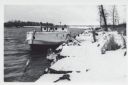
| Date: | 01 06 1958 |
|---|---|
| Description: | View from snowy shoreline of Mooring Basin at bay end of Ship Canal. The boat moored in the foreground is named "Allie." It is tethered to a post on the sh... |

| Date: | 1902 |
|---|---|
| Description: | This map is a chart of Milwaukee Harbor that displays local streets, bridges, roads, railroads, public buildings, businesses, factories, dry docks, parks, ... |

| Date: | 1907 |
|---|---|
| Description: | This map is a chart of Milwaukee Harbor that displays local streets, bridges, roads, railroads, public buildings, businesses, factories, dry docks, parks, ... |

| Date: | 1910 |
|---|---|
| Description: | This ink on paper blue line print base map consists of eight separate pieces and shows city limits, The Milwaukee Electric Railroad & Light Company lines, ... |
If you didn't find the material you searched for, our Library Reference Staff can help.
Call our reference desk at 608-264-6535 or email us at: