 Filter: Categories of Wisconsin Historical Images
Filter: Subject of Canals
Filter: Year of 1800-1899
Filter: Year of 1890-1899
Filter: Categories of Wisconsin Historical Images
Filter: Subject of Canals
Filter: Year of 1800-1899
Filter: Year of 1890-1899

| Date: | 1892 |
|---|---|
| Description: | Bird's-eye map of Princeton, with an inset of the Residence of F.T. Yahr. Fox River loops to left of center, with one bridge; thirty-six businesses, reside... |

| Date: | 1893 |
|---|---|
| Description: | View of the canal area of the Columbian Exposition grounds looking north from near the front of the Machinery building (at left). The South canal is in the... |

| Date: | 1891 |
|---|---|
| Description: | Color illustration of the grounds and buildings of the 1893 World's Fair or Columbian Exposition. |
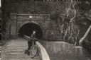
| Date: | 08 1892 |
|---|---|
| Description: | Engraving, probably after a photograph, showing Frank Lenz posing with his safety bicycle near the stone arch entrance of a canal tunnel cut through a moun... |
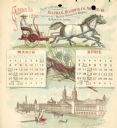
| Date: | 1892 |
|---|---|
| Description: | Second page of calendar for March and April, 1892. Features two illustrations: the top one is of a man using a team of horses to pull a Buckeye harvesting ... |
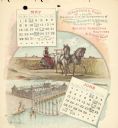
| Date: | 1892 |
|---|---|
| Description: | Third page of calendar for May and June, 1892. Features two illustrations: the top one of a man using a team of horses to pull a Buckeye harvesting machine... |
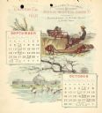
| Date: | 1892 |
|---|---|
| Description: | Fifth page of calendar for September and October, 1892. Features two illustrations: the top one of a man using a team of horses to pull a Buckeye harvestin... |
| Date: | 1892 |
|---|---|
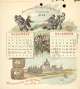
| Description: | Sixth page of calendar for November and December, 1892. Features two illustrations: the top one of a group of boys in a tug of war using twine from a roll ... |
| Date: | 1892 |
|---|---|
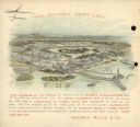
| Description: | Back cover of calendar, with the text: "Hail Columbia, Happy Land!" Features a bird's-eye illustration of the 1893 World's Columbian Exposition (World's Fa... |
| Date: | 1897 |
|---|---|
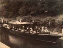
| Description: | View from shoreline of excursion boat docked in a wooded area. From left to right: Mary ??, Elizabeth Layton, Grace Hayman, Henry Wallis (owner of the Fren... |

| Date: | 1891 |
|---|---|
| Description: | This blueprint manuscript map shows land owned by Kaukauna Water Power Co., Green Bay & Mississippi Canal Co., A.W. Patten, N.M. Edwards, and M.J. Meade. P... |
| Date: | 1897 |
|---|---|
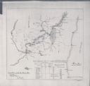
| Description: | This map shows the distances along Fox River, as well as adjacent lakes and railroads, between Green Bay and the Wisconsin River. Lake Michigan is on the f... |

| Date: | 1896 |
|---|---|
| Description: | Front cover and interior of banquet menu for Mexican President Porfirio Diaz, to celebrate the construction of a drainage canal between Lake Texcoco and La... |
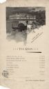
| Date: | 1893 |
|---|---|
| Description: | One-page tea room menu from the Woman's Building at the World's Columbian Exposition. At the top is an illustration of a gondolier steering a couple in a c... |
If you didn't find the material you searched for, our Library Reference Staff can help.
Call our reference desk at 608-264-6535 or email us at:
